Classic July Weather: Your Sunday Weather Briefing
NO WEATHER VIDEO THIS MORNING
A CLASSIC JULY WEEK BEGINS WITH STORMS AND HEAT
Sunday is right on brand for mid-July in Alabama. We’re entering one of the hottest and most humid stretches of the year, and with it comes a daily dose of afternoon thunderstorms. While no organized severe weather is expected, some storms could bring gusty winds, heavy rain, and localized flooding. The heat builds as we move deeper into the week, with triple-digit heat indices likely for much of Alabama by Tuesday and Wednesday. Despite the looming ridge, it won’t be strong enough to shut off rain chances entirely, keeping things sticky and stormy in classic summertime fashion.
SATURDAY RECAP
Saturday was a textbook mid-July day across Alabama: hot, humid, and stormy in spots. Highs ranged from the upper 80s to low 90s, with heat indices into the mid 90s. Scattered storms popped up through the afternoon, producing isolated downpours and a few gusty winds. Storms tapered off after sunset, and patchy fog developed overnight in areas that saw rain.
SYNOPTIC OVERVIEW
High pressure centered over the Deep South is trying to take control, but a weak upper-level disturbance is riding along the northern fringe of the ridge, allowing enough instability and moisture for daily thunderstorm development. A weakening front draped over the Ohio Valley will provide some added lift through Monday, and then by midweek, the ridge begins to reassert itself more forcefully across the Southeast.
SUNDAY AND SUNDAY NIGHT
We’ll see a mix of sun and clouds Sunday with temperatures climbing quickly into the low to mid 90s. With dew points holding in the mid 70s, heat indices will flirt with the 100–105° range by afternoon. Scattered thunderstorms will develop during the late morning and afternoon hours, especially along and south of I-20. Any storm could produce strong gusty winds and torrential rain, but widespread severe weather is not expected. Showers taper off after sunset, and lows will fall into the low 70s with areas of fog possible overnight.
THE WEEK AHEAD
Monday will feature more of the same: highs in the mid 90s, heat indices near 105°, and scattered afternoon thunderstorms. By Tuesday and Wednesday, the ridge strengthens and rain chances drop slightly—but don’t disappear entirely. Highs will range from 94–97°, with heat indices solidly in the 102–106° range. Expect mainly afternoon storms with lower coverage, but plenty of steam and haze. A weak boundary approaches the region by Thursday, possibly increasing rain chances again into Friday, though the overall pattern remains stagnant and summerlike.
NEXT WEEKEND
Early signs suggest next weekend will continue the same theme—hot, humid, and stormy at times. The ridge may weaken slightly as another trough approaches from the north, allowing for a modest uptick in storm coverage by Saturday or Sunday, but don’t expect any major pattern changes.
VOODOO TERRITORY
Looking out into week two, ensemble guidance suggests a gradual eastward shift in the ridge, potentially allowing for a broader northwest flow aloft by mid to late next week. That could open the door to more organized storm clusters riding down the ridge into the Southeast. Confidence is low, but it’s something to watch as we head deeper into July’s second half.
SEVERE WEATHER OUTLOOK
The Storm Prediction Center does not have Alabama in any severe weather risk areas today. However, some storms this afternoon could produce gusty winds up to 40–50 mph and very heavy rain leading to localized flooding.
FLOODING IN THE HILL COUNTRY AGAIN
A flash flood emergency has been issued this morning for the Colorado Bend State Park and surrounding areas in San Saba County, Texas. 6-8 inches of rain has fallen in the past 6 hours making for a particularly dangerous situation.
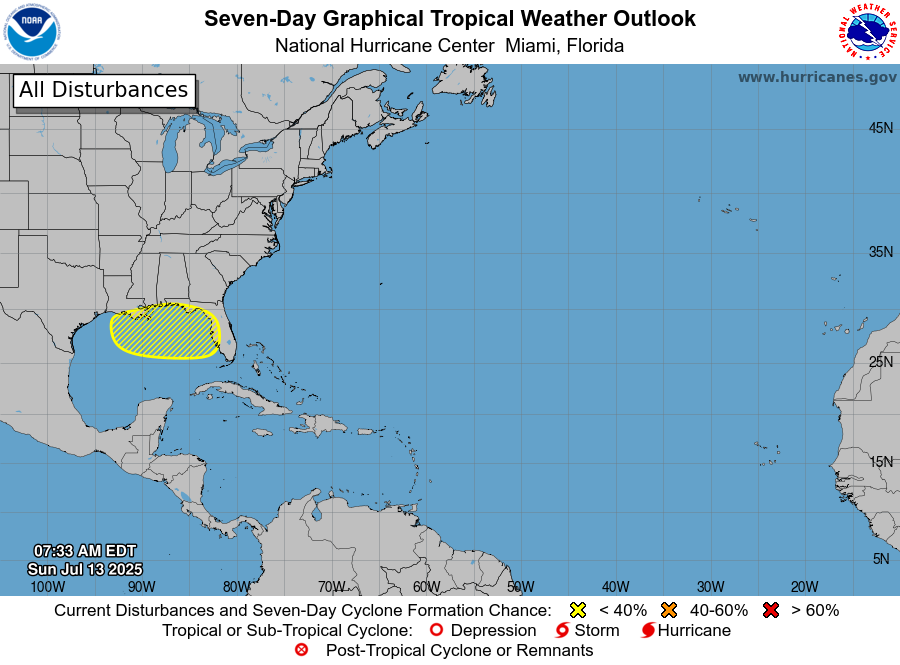
TROPICAL WEATHER OUTLOOK
There is a 20% chance of tropical cyclone development over the northern Gulf during the next seven days as a low drifts out over the water from northern Florida. We will be watching.
BEACH FORECAST
The beautiful beaches of Alabama and Northwest Florida will feature a mix of sun and clouds today with highs near 89–92° and heat indices well over 100°. Scattered storms are possible mainly in the afternoon and evening. Rip current risk is moderate along most beaches. Gulf water temperatures range from 85–87°, so stay hydrated, use sunscreen, and remember to seek shelter if thunder roars.
WEATHERBRAINS PREVIEW
Coming up Monday night on WeatherBrains Episode 1008: we talk with Tom Weber, author of The Weather Detectives, about how forecasting challenges shape our understanding of past and future weather events. Plus, we’ll go behind the scenes with John Banghoff from NWS State College, PA, to discuss life as a lead forecaster and the current training climate.
ON THIS DATE IN 1951…
The state of Kansas experienced its worst natural disaster as the epic flood of 1951 reached its devastating climax. Heavy storms from July 9th to 13th dumped up to 17 inches of rain on top of already saturated ground from an exceptionally wet spring. On July 13, the north end of Topeka was overwhelmed as dikes gave way, with 15 feet of water covering parts of the city. The Santa Fe Railroad’s El Capitan passenger train was stranded at Emporia. Up to 160,000 Kansans were left homeless. Ottawa lost its drinking water plant. Three-fourths of Salina was under water. Kansas City prepared desperately for what was still to come. The 1951 flood remains the costliest in state history and one of the most destructive inland floods in U.S. history.
Category: Alabama's Weather, ALL POSTS, Severe Weather, Social Media
About the Author (Author Profile)
Bill Murray is the President of The Weather Factory. He is the site's official weather historian and a weekend forecaster. He also anchors the site's severe weather coverage. Bill Murray is the proud holder of National Weather Association Digital Seal #0001 @wxhistorianSubscribe
If you enjoyed this article, subscribe to receive more just like it.


