Scattered Thunderstorms Saturday, High Heat Returns Sunday
Screenshot
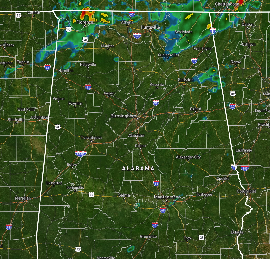
RADAR CHECK
As of 10:45 AM, nearly all of Central Alabama is dry except for a few showers over Cherokee, Etowah, and Cleburne counties. However, multiple showers and storms are covering a good chunk of North Alabama, especially over the AL/TN state line just north of Florence, and around and north of Scottsboro and covering nearly all of Jackson County.
TEMPERATURE CHECK
Rain-cooled air is keeping temperatures in the upper 70s for a good chunk of North Alabama, while much of the rest of the state are in the 80s. Bay Minette down in Baldwin County is currently the hot spot at 90 degrees. Birmingham was at 82 degrees. Tuscaloosa and Anniston were at 84 degrees. Huntsville was at 78 degrees. Mobile was at 88 degrees.
REST OF YOUR SATURDAY
North Alabama: A deep, tropical airmass remains in place today as high pressure drifts back toward the Florida Peninsula. Southeast winds continue to feed moisture into the region, and with that, we’ll see scattered showers and thunderstorms through the afternoon and into the evening. A few storms could be slow-moving, and with such high humidity, heavy rainfall is likely. Flooding could become a concern where storms train over the same area. Cloud cover and rain will help hold temperatures in the mid to upper 80s this afternoon, but the air will still feel very humid with dewpoints in the upper 70s. Showers and a few storms may persist into the overnight hours, particularly across the northern counties. Be alert for locally heavy rain this evening and overnight.
Central Alabama: Through the afternoon and evening, expect most of the rain and thunderstorm activity to remain north of I-20, though isolated cells can’t be ruled out farther south. Rainfall could be locally heavy under the strongest cells. Temperatures this afternoon will range from the upper 80s to low 90s across the north, with the low to mid 90s farther south where rain is more limited. A few storms could linger through sunset, but most of the area should dry out overnight.
South Alabama: Today’s rain chances are noticeably lower, and most areas will stay dry through the afternoon and evening hours. A stray shower or storm is still possible, mainly near the coast, but activity will be widely scattered at best. Skies remain partly cloudy to mostly clear tonight, with a mild and muggy overnight ahead. Temperatures this afternoon will climb into the low to mid 90s, and it’ll feel hotter thanks to rising humidity. Conditions remain quiet overnight with no significant weather expected.
SUNDAY’S FORECAST
High pressure will remain parked near the Gulf Coast on Sunday, allowing a hot and humid airmass to persist statewide. While most of the state will see only isolated to scattered afternoon storms, the highest rain chances will be across North Alabama where deep tropical moisture continues to stream in. Any storms that form may produce locally heavy rain, gusty winds up to 50 mph, and frequent lightning. The Weather Prediction Center maintains a Marginal Risk for flash flooding across northeast Alabama, where saturated ground may also lead to downed trees during storms—even without severe wind gusts. Temperatures will climb into the low to mid 90s in central and northern counties, with upper 90s possible across the south. Heat index values will range from 100 to 105 degrees during the afternoon. Storm coverage will taper off after sunset, with a warm and muggy night ahead and lows in the low to mid 70s.
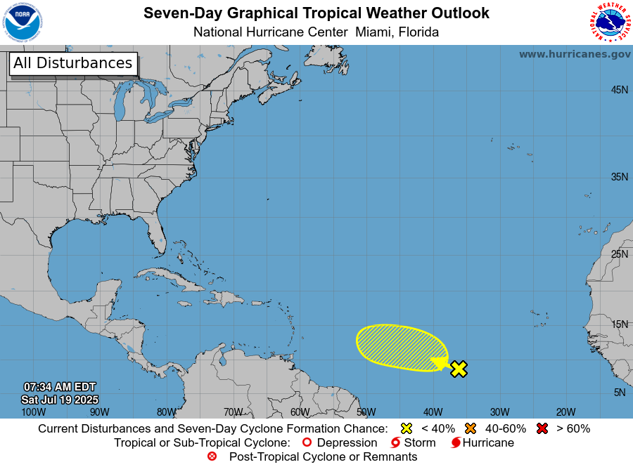
TROPICAL UPDATE
A tropical wave in the central Atlantic, located roughly 900 miles west-southwest of the Cabo Verde Islands, is currently interacting with a broad area of low pressure. This disturbance is producing disorganized showers and thunderstorms as it tracks west to west-northwest at about 10 mph. Environmental conditions are only marginally favorable for development over the next few days, and by the middle of next week, conditions are expected to become less supportive. As a result, the National Hurricane Center gives this system just a 10% chance of development over the next 48 hours, and a 20% chance over the next seven days. At this time, no immediate threat to the Gulf of Mexico is expected, but we’ll continue to monitor for any changes.
Category: Alabama's Weather, ALL POSTS, Social Media
About the Author (Author Profile)
Scott Martin is an operational meteorologist, professional graphic artist, musician, husband, and father. Not only is Scott a member of the National Weather Association, but he is also the Central Alabama Chapter of the NWA president. Scott is also the co-founder of Racecast Weather, which provides forecasts for many racing series across the USA. He also supplies forecasts for the BassMaster Elite Series events including the BassMaster Classic.Subscribe
If you enjoyed this article, subscribe to receive more just like it.


