Dean Headed Toward Category 5
Powerful Hurricane Dean continues to plow westward at over 20 mph. He has the great advantage of super rich ocean temperatures that will make any tropical storm or hurricane smile. Here is the latest vital information based on the 10:00 a.m. (Alabama time) Advisory.
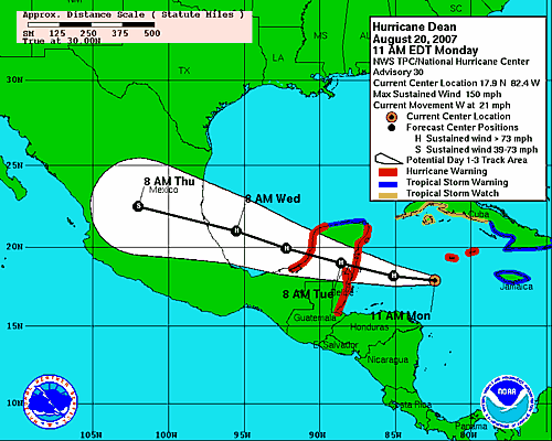
LOCATION / MOVEMENT
Near latitude 17.5N, longitude 82.4W or about 125 miles SW of Grand Cayman and some 385 miles east of the Belize City. The monster was moving west at 21 mph. A west or WNW is expected over the next 24 hours. This means that landfall will be on the Yucatan Peninsula early Tuesday morning. However, conditions will worsen well ahead of the landfall.
WINDS / PRESSURE
Sustained winds are near 150 mph with a lot higher gusts. Dean is stil considered a Category 4. There is a good chance he will reach Category 5 before making landfall. Estimated minimum pressure 925mb or 27.32 inches.
SPECIFIC WARNINGS
Hurricane Warning now posted for the west coast of Yucatan. It was already in effect for the east coast. This means hurricane conditions are expected within the warning area within the next 24 hours. Hurricane Warning has been extended on the east coast of the Yucatan from Belize City to the border with Guatemala. This means a Hurricane Warning now in effect for all of Belize. A Tropical Storm Warning extends from north of Cancun to Progresso. The Government of Jamaica has replaced the Hurricane Warning for Jamaica with a Tropical Storm Warning and even that may be lowered early this afternoon. The damage has already been done and from all reports it is extensive on Jamaica.
ALABAMA IMPACTS
The National Weather Service in Mobile advises that due to larger swells moving north from the Yucatan channel Tuesday and Wednesday, that a High Surf Advisory may be needed for the Alabama coast. There may also be a Moderate to High Risk of rip currents late Tuesday into Wednesday. The NWS will address that more specifically as the picture becomes clearer. The current forecast calls for 6-7 foot seas along the Alabama coast tonight and Wednesday.
TRACKING MAP
Check out the latest track forecast below. It is self-explanatory and note that there are persistent indications that the USA will not be affected:
Category: Uncategorized
About the Author (Author Profile)
Subscribe
If you enjoyed this article, subscribe to receive more just like it.


