Marginal Severe Weather Threat Ahead

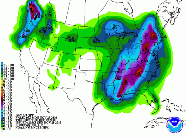
Rainfall amounts through Tuesday evening.
It looks like we will deal with a typical late season low instability, high shear severe weather threat late Monday night into Tuesday morning across Central Alabama.
There is a good bit of uncertainty about the situation, especially since our two main models have differences in instability.
They are in agreement that a surface low will move from near the Kansas/Nebraska border tomorrow morning into Iowa by tomorrow night. A warm front will move north during the day, reaching Central Alabama late Monday evening. Showers will be possible Monday morning, increasing during the afternoon. There will be some embedded thunderstorms during the day, with thunderstorms becoming likely with the warm front as it lifts northward.
Winds will be out of the east during the day, then become southeasterly and increase Monday night. Highs on Monday afternoon should be between 58-60F. Lows Monday night will not drop very much, ranging between 53-55F.
The GFS depicts little instability in the warm sector behind the front, but the NAM model is more aggressive. If the NAM model turns out to be correct, CAPE values will be between 500-750 j/kg2 over West Central Alabama during the early morning hours. Both models show decent levels of wind shear, so any updrafts that form will likely rotate. In addition, low level shear will be high which means we will have to be alert to low topped thunderstorms that can produce small spin up tornadoes.
The biggest risk is between 10 p.m. Monday night and 10 a.m. Tuesday. The primary threat area will be south of a line roughly from Greensboro over to Clanton and Lafayette.
The good news is that rainfall amounts will be decent, with most spots in the northern half of the state logging between 2 and 2.5 inches of rain between Monday morning and sunset Tuesday. Over South Central Alabama, amounts will be between 1.5 and 2 inches.
Frontal passage should occur at Birmingham during late morning Tuesday with diminishing rain after that. Colder air will flow in starting Tuesday afternoon. Most of the precipitation should be gone before the cold air is entrenched enough to allow for any show flurries. Readings will bottom out near freezing Wednesday morning.
Category: Alabama's Weather


