Saturday Sleet
Many folks woke up to the sound of sleet bouncing off their decks and windows and striking the leaves around their homes and apartments on this Saturday morning. Sleet is like the Rice Krispies of the weather world, with lots of snap, crackle and pop, but fortunately its not really hazardous. Having said that, if you get a layer of it on a deck, porch or sidewalk, it can be extremely slippery, so be very careful out there if sleet showers have left a deposit on one of those surfaces that you have to walk over this morning.
TEMPERATURES: Readings overnight flirted with 32F for awhile, and fortunately there was a layer of cold air near the surface was thick enough to allow the precipitation to refreeze before it hit the ground, giving us the sleet pellets rather than freezing rain. And for the most part, temperatures only hit freezing for a short while briefly.
TRAVEL PROBLEMS: Haven’t heard of any this morning, but there could be some icy spots on bridges in a few spots over Blount, northern St. Clair, southern Etowah, Calhoun, Cherokee and Cleburne Counties, so check local conditions before venturing out.
IMPROVING CONDITIONS: Temperatures will edge into the middle and upper 30s rather quickly, so any problems should be short lived.
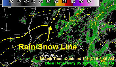
DYING SNOW FLURRIES OVER NORTH ALABAMA: The only place where the temperature profile became supportive of snow was over Northwest Alabama, where the 0C isotherm at 5000 feet has now fallen to a line from Millport to Decatur, but the moisture has pretty much moved out of those areas, so any flurries will be light and brief and limited to areas from Lawrence and Winston Counties into the Huntsville/Decatur area then into Northeast Alabama’s Jackson County perhaps.
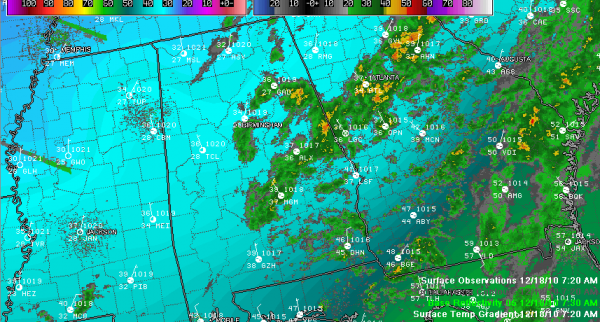
RAIN TO THE SOUTH: Rain was east of a line from Bessemer to Centreville to Selma by 7:30. The back edge of the rain is moving east at about 25 mph and will be into Georgia for the most part by noon.
CLEARING NOT FAR BEHIND: The clearing line is already into Northwest Alabama with a little sun already evident at Muscle Shoals.
MEMPHIS SNOW: Memphis picked up a little less than one half inch of snow on the backside of the system last night. The official report from Memphis International was 0.30 inches of snow. When melted down, the equivalent was 0.02 inches of liquid precipitation.
Category: Alabama's Weather


