Ice and Snow Possibilities
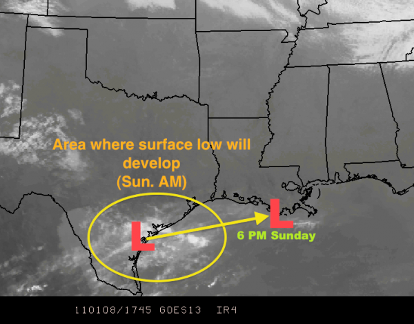
Over the past few hours, you have seen changes to the forecast. Heavier snow positioned to the north, icy conditions to the south. We still have not seen the development of a surface low over Texas yet. That happens tomorrow morning. Here is the current satellite image and some notations to show where the low is expected to form:
The precipitation type, as Dr. Tim Coleman explained in a post earlier this morning (you can see it by clicking here) has everything to do with temperature at the surface and through the first few thousand feet of the atmosphere.
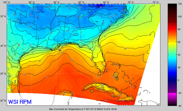
Arctic air has moved deep into Alabama this morning. The dewpoint in Birmingham has dropped into the teens with a temperature in the mid-40s. Arctic air is dense, and oftentimes, forecast models over-do the retreat meaning it is colder than the computers know. Here is the RPM temperature projection for midnight tomorrow night/Monday morning:
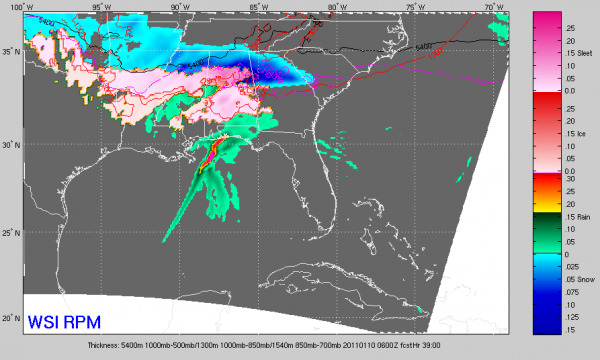
That shows a rise in temperature (and dewpoint) to near or just below freezing for most of Central Alabama while light to moderate sleet or freezing rain is falling. Snow would be more likely in the deeper cold air to the north. This is the RPM’s forecast radar data for the same time period:
Model imagery like that would lead you to believe that there appears to be a greater threat of mixed precipitation (with an emphasis on the potential for significant amounts of ice accumulation) where you see the pink shading. The current snow/ice ranges look pretty good, but there will still be some adjustments. Ice is becoming a greater in Tuscaloosa, Bibb, Greene, Hale, Shelby, Chilton, Coosa, and Talladega Counties (as well as the counties south of there all the way to US Highway 80 from Selma to Montgomery and then up toward the Auburn-Opelika area).
Birmingham/Jefferson County will still see a mix of precipitation that will eventually change over to mostly snow. The farther north and east you are (Hoover less, Gardendale-Trussville-Clay more), the more likely it is that you will have more than 2-3″ of snow (and it could be a LOT more).
In the areas generally north of I-20 (generally means this is not a direct cut-off point…just a land mark), heavier snow amounts will still reach up above 6 inches. The closer to I-20 you are, the less likely you will have the max, but places around Cullman, Jasper, and Gadsden are more likely. We also have to account for the rugged terrain of eastern Alabama, so from Sylacauga northeast into Ashland, Anniston, Heflin, and Roanoke, you will see more of a mix that could change to heavy snow at times.
Remember, the mixture will reduce the amount of actual accumulation on the ground. If 1.00″ of liquid falls, and 50% of it is sleet and rain, you cannot use the 10:1 snow/rain ratio. It would be more like four inches of slushy, icy mess.
I want to reiterate that when the low develops and we see the conditions develop in Mississippi, we will be able to make the final true adjustments to the lines that will most accurately represent the kinds of conditions you will have by Monday morning.
This still has the makings of a major winter storm whether you get the 6″+ snow or a 1/4″+ inch of freezing rain. The biggest things that change there are power outages and what it looks like. They are both very significant issues.
-Jason
Follow me on Twitter: @simpson3340
Category: Alabama's Weather, Winter Weather


