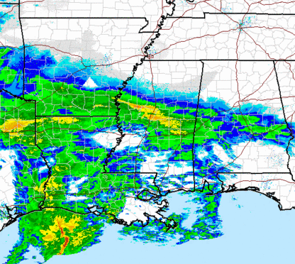
Winter storm analysis – 1200 pm
Major winter storm already coming together to our west. An upper level disturbance is moving out ahead of the main storm, creating the early band of precipitation across central MS and moving into central AL. Even though some of this precip is evaporating before reaching the ground due to the dry air in place, many spots in west Alabama have already reported sleet or freezing rain, and bridges are already icing in Sumter County. As the atmosphere slowly moistens up, more of the precip will start making it to the ground farther east. It should mainly be light, but temperatures are very cold (still in the 20s in BHM), and a few slick spots could develop this afternoon, so be careful.
The big event will start around sunset, and the precipitation may be heavy sometime late this evening. The precipitation type is the main concern at this time. Areas like MGM, AUB, Troy, and Clanton are in for an ice storm, with up to 0.5″ of ice accumulating. This could bring down a lot of trees and powerlines. Farther north, we’re watching the I-20 area (TCL, BHM, ANB) for the possibility of a changeover from snow to ice around midnight or so, decreasing snow amounts and increasing ice amounts. The UAH microwave profiling radiometer has been showing warming already occurring aloft since 8 am. The wet bulb effect will cool the atmosphere at first, giving people from Clanton north snow. But, as the strong low-level southerly jet just above the surface kicks in tonight, temperatures will warm aloft, and the snow north/ice south line will move north. We can not say exactly how far north it will move, but it looks like parts of Pickens, Tuscaloosa, Shelby, Jefferson, St. Clair, and Calhoun counties may also get some ice accumulation that could cause power outages. We’ll have to watch temperature profiles very closely, because the BHM metro area will be right on the border.
For snow fans…the best chance of a big snowfall is from BHM north, where 4-8″ of snow will fall. Here in BHM, being so close to the ice/snow line, how fast it changes over to ice will determine how much snow falls here. Right now we’re going with 2-3″.
Category: Alabama's Weather


