Tuesday Morning QB
I posted a version of this late Sunday night, but since many didn’t see it due to the late hour, here is another look back at the forecast for this event, and how it verified.
Some trolls were screaming “bust”, so let’s take a look at the actual forecast here, versus what happened.
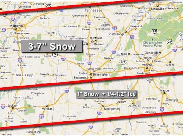
Our final forecast, 24 hours before the event, is below…
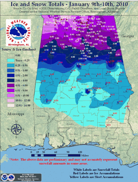
The final observations are below from the NWS…
The main problem with the forecast was that the middle line was 25 miles too far south. That is the line between 3-7 inches of snow, and 1″ of snow with 1/4-1/2″ ice. That was a clear error, no doubt about it. Humility is missing in great doses in our science, and I am amazed at those that don’t admit they ever are wrong, or even CAN be wrong. But, the middle red line placement was wrong. By 25 miles.
But, having said that, I did my best to communicate here that we had little skill in identifying the line between ice and snow with events like this. And, quite frankly, I don’t think I will ever beat a 25 mile error. Unfortunately, that 25 mile error was right over the cities of Tuscaloosa and Birmingham, so it sure impacted plenty of people. It was a very sharp line between snow and ice, as the models had identified nicely in the days leading up to the event.
In the Birmingham metro, there was very good snow cover in places like Warrior, Mount Olive, Bagley, Gardendale, Trussville, and Clay. But, to the south, it was mostly freezing rain and sleet for Hoover, Pelham, and Alabaster. Turned out I-20 was indeed the best dividing line with this event.
I should also note that I was not aggressive enough with the snow amounts north of I-20. Totals of 8-10 inches were fairly common over the Tennessee Valley, well above the 7 inches on the top end in the forecast.
Now that the event is over, the trolls are mostly gone (and won’t come back until the next chance of wintry weather), and they honestly don’t care to look at this assessment of the forecast, but I can honestly say that I don’t know if we can do much better with this kind of event, considering the complexity of precipitation type and timing.
And, of course, very few remember the two things I say about every winter weather event in Alabama…
*Some will be delighted with the amount of snow they see, and others severely disappointed.
*There will be surprises.
You can do a search on the blog and find these two lines in place before EVERY winter event. I guarantee you these two bullet points will verify every time.
We do our thing here every day of the year, weekdays and weekends, and do our best during events like this to kick it up a notch to provide opinion and discussion from all of the meteorologists that write here. Most are much smarter than I am, and I am proud to work with them. It has always been my goal to simply to tell you what I think is going to happen… nothing more and nothing less. And, for those that kept up with the blog and followed along, I think you were pretty prepared for what you got.
And, I should finally mention, the trolls don’t bother us. J.B. and I are old as dirt and have gone through many trolls over the years. They come and go, and some of them are actually decent people that are just maybe are struggling with issues thrown their way. We will be attacked from them whether they we are right or wrong, and they usually only come out when it is cold, thank goodness.
Category: Met 101/Weather History, Winter Weather


