Complex Situation

Please click for a closer look…
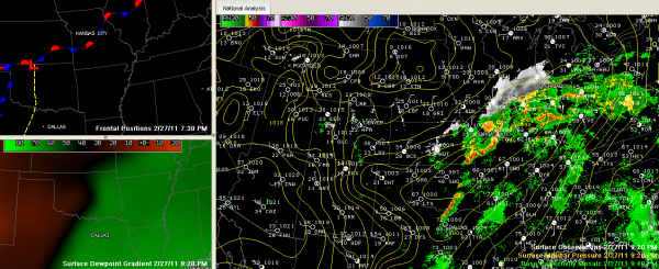
This is a complex severe weather situation developing to our west tonight. Let’s see what we can discern.
…A series of disturbances is moving northeasterly in the deep flow tonight from the Texas Panhandle to Illinois. Severe thunderstorm warnings are occurring over Illinois. Another is approaching Kansas City tonight, but those storms are not severe. Another is near Wichita, producing storms that are prompting severe thunderstorm and tornado warnings. All of this activity is occurring along a wavy stationary front. The further you go south of this boundary, the more the atmosphere is capped, keeping a lid on thunderstorm development.
…A 998 mb surface low is over northeastern Oklahoma. It is the southern anchor or an elongated low pressure system that extends to an additional center over Illinois. Storms were firing over southern Oklahoma and northern Texas in association with a prefrontal trough and dryline that extends southward out of this low.
…Closer to home, another upper level disturbance was pushing across western Tennessee…trailing an area of showers into eastern Mississippi and western Alabama. The airmass over Mississippi and Alabama is strongly capped, as evidenced by the 6 p.m. balloon releases from Jackson and Birmingham which both show pronounced warming at about 10,000 feet. Instead of temperatures falling with height, when they reach that level, they actually rise. This puts the kibosh on upward motion, suppressing thunderstorm development.
…The atmosphere over Alabama is actually slightly unstable tonight, with CAPEs running about 400 j/kg2 and lifted indices around -2C. That cap is evidenced by near 200 j/kg2 of convective inhibition. That cap should remain in place until something moves it out tomorrow.
Let’s piece a solution out of this information:
…Thunderstorms should intensify overnight as they move into Arkansas and Missouri is association with the surface low moving out of Oklahoma. The best dynamics will lift northeastward, taking the best chances for severe weather with it.
…As the southern part of the line of storms moves east, it will weaken as it approaches the Mississippi River just after daybreak. It does appears that severe storms will hold together as they move into northeastern Louisiana, northern Mississippi and western Tennessee between 5-8 a.m. in the morning.
…A few showers may form again during the pre-dawn hours across much of Alabama, but they should not be significant as the cap will likely still be holding firm early in the morning.
…Things will quieten down across Mississippi and remain quiet across Alabama until at least late morning.
…Moisture levels will continue to creep up, with dewpoints approaching 62-65F across West Central Alabama during the morning hours. Skies should remain mostly cloudy, but temperatures will warm into the 70s. This will push CAPE values (instability) into the 750-850 j/kg2 range.
…It will be breezy, with southerly and southwesterly winds averaging 10-20 mph with gusts to 30 mph. Tonight’s wind advisory will continue for much of the day tomorrow.
…The pre-frontal trough will be approaching the state during the late morning and storms will refire. They should reach a line from Huntsville down to Tuscaloosa just after lunch, reaching I-59 around 2-3 p.m. It appears that the storms will be strongest over the Tennessee valley, perhaps reached down into Northeast Alabama around Gadsden. A little further south, in the Tuscaloosa and Birmingham areas, the storms may have a little harder time surviving, but any that do will have sufficient wind shear to become organized and severe.
…The good news…at least for Tuscaloosa, Birmingham and Anniston, is that low level wind profile do not look like they will be supportive of significant tornadoes. Can’t rule out an isolated one, but the best chances for tornadoes may well be much farther north, from the Tennessee Valley north.
…The wild card is that if a deeper low with a more southerly track materializes, say through Arkansas and western Tennessee, we could deal with more helicity or spin in the atmosphere and the tornado threat would be enhanced slightly over Central Alabama.
…The cold front should arrive in Birmingham by late afternoon. Dewpoints will crash and temperatures will fall to near 40 by morning, with 30s in the normally colder locations by Tuesday morning. Tuesday highs will be in the lower 60s.
LATE NOTE
The GFS is now out to 24 hours and it tends to confirm this solution. We will keep an eye on the situation overnight and keep you posted if anything changes or develops. And we will have frequent blog updates all through the day on Monday.
Category: Alabama's Weather, Severe Weather


