Severe weather – 145 am
(130 am)
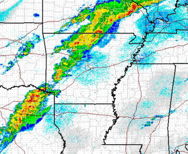
A strong cold front with a line of storms ahead of it extends from eastern Missouri, across western Arkansas, into Texas early this morning. The cold front will continue to move southeast, making it to BHM by late afternoon.
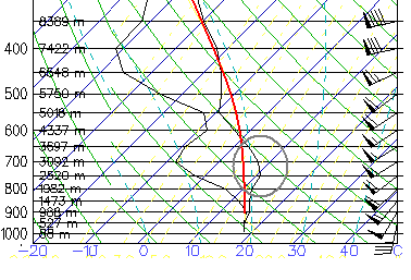
As Bill noted a few hours ago, this is a complex situation. It feels like severe weather outside…with temperatures near 70 in the middle of the night and dewpoints in the lower 60s. However, early this morning in BHM, there is a layer of warm air, known as a cap because it keeps a lid on thunderstorm development. It should remain in place until 9 am.
This is the computer model expected sounding at 9 am. The black lines are actual temperature and dewpoint, and the red line is the temperature of an air parcel rising in a thunderstorm. For storms to form and get strong, the air parcels need to be warmer than their environment (so they are buoyant). The warm air between 800 and 650 mb (circled) would prevent most storms from forming at that time, since the parcels would be cooler than their surroundings and try to sink. However, as dynamics ahead of the front move in and cool things off aloft, the cap will disappear, allowing storms to move through here anytime after about 10 am or so, and earlier in NW Alabama.
So, as the front approaches, we expect scattered showers and storms to develop out ahead of the line, over NW Alabama as early as this morning, and in BHM by noon or 1 pm. Then, the main line of storms will move through the state this afternoon.
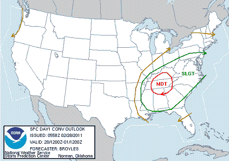
Once again, it looks like the most widespread threat will be damaging straight-line winds, with wind at 5,000 feet near 70 mph, and thunderstorms bringing that wind down to the ground, knocking down trees and power lines. The question right now is how far south the tornado threat will extend. For significant tornadoes, the wind must change direction and speed with height (helicity). If the surface low stays way to our north, surface winds will veer around to the SW, reducing helicity and the tornado threat, especially south of Cullman. However, we are watching pressures falling this morning over Arkansas, as another upper-level disturbance moves in there. If another low can form and move across Tennessee, this would keep winds out of the south longer, and there could be a bad tornado threat in north Alabama, and a tornado threat as far south as TCL, BHM, and ANB. We don’t know yet.
Main thing is, have a source of weather information handy today and check it often. Either way, we will see a line of strong storms with damaging winds this afternoon. If the low forms and moves across Tennessee, tornadoes may be a major problem, especially in north Alabama. Tornado watches will likely be in effect for much of the day across north and central Alabama.
Category: Severe Weather


