Severe Weather Possible This Afternoon and Evening
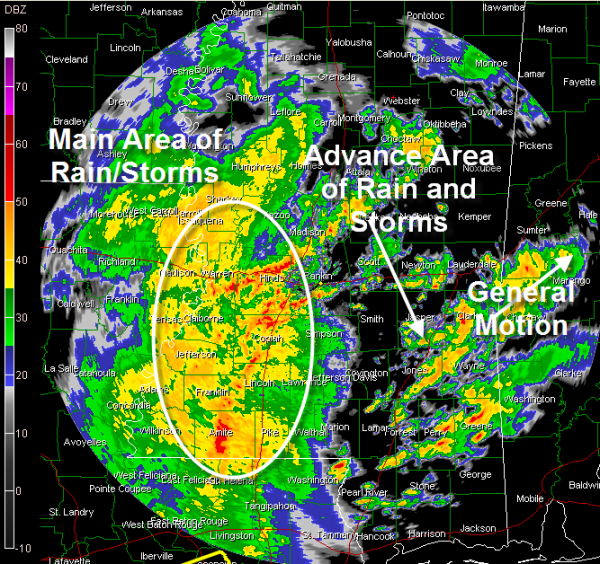
Here is a look at the Jackson MS radar at this hour…
Severe weather is possible across parts of Alabama this afternoon and evening as a storm system pushes through the state.
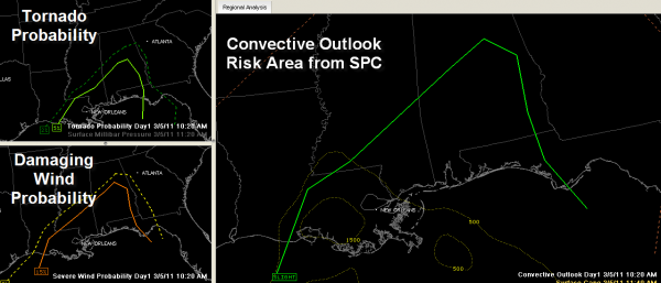
Here is a chart showing the SPC covective outlook slight risk area in the larger panel, the tornado probability (within 25 miles) in upper left and damaging wind probability in lower left.
Here is what’s going on…
A surface low is now over southwestern Louisiana. An upper level trough is pushing east through Texas.
A widespread area of rain and thunderstorms covers much of southeastern Arkansas and eastern Louisiana and is pushing into western Mississippi in association with the surface low. This large rain/thunderstorm mass will affect much of Alabama later this afternoon and evening.
The low will move north northeast through Mississippi and into northwestern Alabama this evening.
Over North and Central Alabama, moderate rain covered much of Marion, Lamar, Fayette and pushing into Winston County. This activity was moving northeast.
Over Central Alabama, a cluster of showers was over Autauga, Coosa, Tallapoosa and Elmore Counties. It was also moving northeast.
Little, if any lightning in these two masses of rain.
Over Mississippi, showers and thunderstorms were breaking out ahead of the main rain/storm area from the Mississippi Coast up to Meridian, with additional showers growing up to around Kosciusko. This activity was starting to push into Choctaw County around Butler, where there was a good bit of lightning. It will lift into Sumter County around Livingston over the next 30 minutes. It will eventually reach Tuscaloosa in a couple of hours and the Birmingham area by midafternoon.
This advance activity is associated with warm, moist air lifting north on the front side of the surface low. This area of increasing instability will bring its own wind shear along with it, thanks to the proximity of the surface low. This means a threat of severe weather between noon and 6 p.m. for areas south of I-59 and west of I-65. The threat for areas south of I-20 and east of I-65 should come after 5 p.m.
Bottom line, the best chances for severe weather will be south of a line from Butler to Marion to Clanton to Rockford to Ozark, with an isolated severe weather threat for areas as far north as I-20. North of I-20 there will be quite a bit of heavy rain with thunder, and we can’t rule out a stray severe storm.
A tornado watch remains in effect for Southwest Alabama. No tornado warnings in effect right now. There are some severe thunderstorm warning that have just been issued in Louisiana.
Category: Alabama's Weather, Severe Weather


