JB’s Journal–The Brent Tornado
It was late afternoon on a Sunday on May 27, 1973 and a major weather
tragedy was about to unfold in West and Central Alabama. Around 5:20 pm,
Alabama State Troopers reported that a tornado had touched down north of
Demopolis. It was destined to become a major tornado that would cut a path
longer than any other single tornado on record in Alabama-over 100 miles.
This story concerns mainly the actions taken by the Birmingham National
Weather Service Forecast Office, located at that time at 11 West Oxmoor
Road. I was on duty along with several others during that tragic event and
it was truly a nail-biting time. To set the stage.
* There was no doppler radar in those days and no radar at all on station
at Birmingham. Instead, powerful radars across the country were set up on a
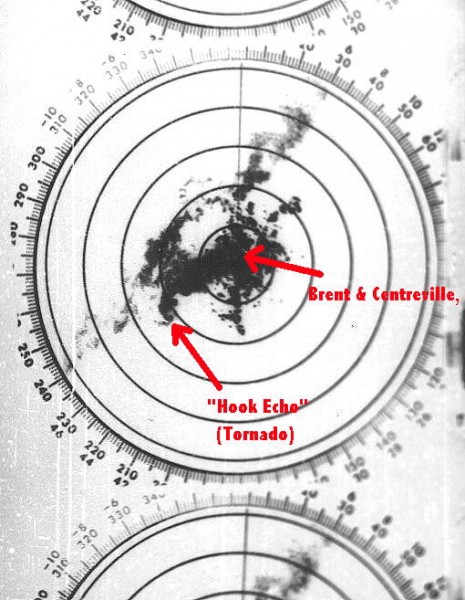
grid basis. One of those was known as Centreville Radar. It was located on
a ridge on highway 25 southwest of Centreville and Brent. They also launched
weather balloons from Centreville for upper air soundings and took regular
weather observations.
* Communication between the Centreville station and Birmingham was by open
line telephone, no dialing necessary. There was also a continuous fax
circuit between the two locations. Every five minutes or so we would
receive a fax of the Centreville radar scope. It was rather poor quality. To help
us, the radar operators at Centreville would post notes on the image
outlining the location of the strongest thunderstorms and their direction
of movement. There was also an unexpected problem with the fax system. When a
certain teletype circuit in our office at Birmingham would start
transmitting information, it would cause the fax pictures from Centreville
to partially break up and become distorted. So we leaned heavily on the
open telephone circuit.
* We also had another open line phone system with speakers. All Alabama
State Trooper posts were on the system, as well as sheriff’s offices, some
police departments and Civil Defense. (later known as EMA. The speaker
could be heard all over our office. We could also pick up that phone and request
information from any of those.
* Ham Radio operators have always been a huge help. Some of them were
mobile and could go to remote locations and serve as storm spotters.
* We already knew that weather conditions were quite unstable and we were
on alert for possible severe weather.
* We got a report via NAWAS (name of the system described above linking
various offices on a voice line.) The report was from the Demopolis State
Trooper Post that a tornado had touched down north of Demopolis. We
immediately issued a Tornado Warning. From that moment on, the staff at the
Centreville NWS went into action keeping us informed on an almost
continuous basis of the location and movement of the main thunderstorm containing the
tornado. It was an enormous effort and we will never be able to thank Dale
Black (the Meteorologist in Charge) and his staff enough.
* The tornado continued northeast and struck the southeast part of
Greensboro. Significant damage and one person was killed.
* From that point on, the tornado seemed to favor Alabama state route 25 at
times. It moved across part of the Talladega National Forest uprooting
thousands of trees and continued seemingly on a path toward the Centreville
Radar Station. The staff there was giving us almost “play by play” on the
open telephone circuit. At Birmingham. we were updating the warnings and
issuing additional Severe Weather Statements that went out over a statewide
teletype circuit to media outlets and others.
* Then came this dramatic and chilling report from Centreville Radar on the
open phone line: “We have been hit! The roof is partially gone. The radar
dome has been sheared off!” Fortunately, by quickly retreating to a safer
room in the building there were no injuries in the building.
* We immediately reissued the Tornado Warning for Bibb County with extra
urgency and warned that it was heading directly toward Brent and
Centreville.
So, on that tragic afternoon and evening, the tornado moved from north of
Demopolis to Greensboro and then to Brent. It moved through the heart of
Brent as a powerful F4 tornado causing massive destruction. It struck the
Brent Baptist Church while Sunday evening services were in order.
After leaving Brent, the tornado continued barely missing the heart of
Centreville. Then it was onward, still near highway 25 and passing near
Montevallo, Calera, Wilsonville and finally breaking up on the west slope
of Mount Cheaha in East Alabama. The path was over 100 miles. The powerful
tornado left behind these stats:
* One fatality and 72 injuries at Greensboro
* Five fatalities and 56 injuries in Brent
* Estimated 90% of Brent destroyed or heavily damaged
* 216 buildings destroyed and 570 damaged in Brent
* 97 mobil homes destroyed
* 45 business establishments destroyed or dmaged
* 12,000 acres of timber destroyed along the path.
* Total for the day.7 dead and 199 injuries.
Next day was a trip to Brent and Greensboro as part of a storm survey team
and I did a lot of photography.
It was one of those days in my 32-year career in the U.S. Weather Bureau,
later known as the National Weather Service which I can never erase from my
memory bank.
Category: Alabama's Weather, Met 101/Weather History


Comments (1)
Trackback URL | Comments RSS Feed
Sites That Link to this Post