Suddenly Active
The Atlantic basin has suddenly sprung into life.
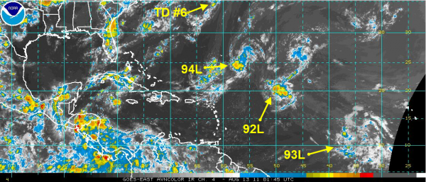
Tonight the Atlantic looks like the Air Traffic Control radar in Atlanta with tropical systems lined up across the ocean. Late this afternoon, Tropical Depression #6 formed north of Bermuda. It will likely become Tropical Storm Franklin by tomorrow morning, but it is expected to continue moving off to the east northeast, away from the United States.
The other three disturbances are lined up north northeast of the Lesser Antilles (94L), about 900 miles east of the northern Leewards (92L) and midway between the islands and Africa (93L). These systems all have a chance of developing into a tropical cyclone over the next 48 hours.
92L and 94L could threaten Bermuda, but won’t affect the U.S. And the long range models do predict that another Cape Verde system will form in the far eastern Atlantic in about two weeks.
There are signs that this early part of the season will be dominated by a trough over the eastern U.S. and eastward displaced Bermuda High, meaning the storms will favor the East Coast or recurvature.
Hopefully, that will be the case, but there are signs that 93L could make a long westward cruise across the Caribbean and threaten the southern Gulf of Mexico in 10-14 days from now.
Category: Tropical


