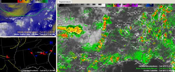
Strong Storms Over West Alabama
Fairly typical conditions for this time of August in Alabama with partly cloudy skies and seasonally hot temperatures in the lower 90s.
A line of thunderstorms had formed along the Mississippi/Alabama border from Franklin County down to near Meridian MS. This line of storms is pushing eastward at 20 mph. The NWS has issued significant weather alerts for the storms across Fayette, Lamar, Marion, Pickens and Winston Counties.
The storms have formed ahead of an upper level disturbance that is pushing eastward. The airmass ahead of the storms is unstable, but wind shear is low. So we will see fairly typical summertime pulse thunderstorms, which strengthen quickly and collapse just as quickly. Damaging wind gusts are possible and there could be a few warnings, although a weather watch is not anticipated.
Jeff Drake, our Skywatcher in Bessemer, sent these photos of the thunderstorm anvils, which were about 90 miles west of his location. Wow!
A few other storms were forming in the area southeast of Birmingham.
More storms will push through tonight ahead of a cold front that will push across the area overnight.
Category: Alabama's Weather


