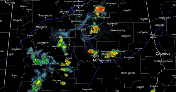
Approaching 6 p.m.
At 6 o’clock, showers/storms were widely scattered across Central Alabama. One was in the Gadsden area. Another was near Childersburg and yet another was northeast of Clanton.
Others were scattered along the US-80 corridor in Central Alabama from Perry and Dallas Counties through Autauga and Montgomery Counties.
Everything was pushing east southeast.
None of the storms are very strong at this hour.
The storms that were stronger earlier over West Alabama just fell apart as they moved eastward into less unstable air in the middle of the state.
We will be watching for thunderstorm development later tonight ahead of a cool front that will push into the state during the overnight hours. Any overnight storms should push into South Central Alabama by morning by early tomorrow morning. Slightly cooler and noticeably drier air will follow in the wake of the front for Sunday afternoon, Monday, Tuesday and Wednesday. Overnight lows will be in the 60s Monday through Thursday mornings.
Category: Alabama's Weather


