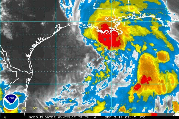
Lee at 10 p.m.
BULLETIN
TROPICAL STORM LEE ADVISORY NUMBER 6
NWS NATIONAL HURRICANE CENTER MIAMI FL AL132011
1000 PM CDT FRI SEP 02 2011
…LEE MOVING SLOWLY NORTHWARD…HEAVY RAINS SPREADING OVER PORTIONS
OF THE NORTHERN GULF COAST…
SUMMARY OF 1000 PM CDT…0300 UTC…INFORMATION
———————————————–
LOCATION…28.2N 91.6W
ABOUT 165 MI…265 KM WSW OF THE MOUTH OF THE MISSISSIPPI RIVER
ABOUT 150 MI…240 KM SE OF CAMERON LOUISIANA
MAXIMUM SUSTAINED WINDS…45 MPH…75 KM/H
PRESENT MOVEMENT…N OR 360 DEGREES AT 5 MPH…7 KM/H
MINIMUM CENTRAL PRESSURE…1000 MB…29.53 INCHES
THE LATEST ON LEE…
Tropical Storm Lee is centered about 90 miles south of the Central Louisiana coast late tonight. It is moving north at 3 mph. Top winds are around 45 mph. Lee is expected to approach hurricane strength on Saturday as it pushes closer to the mainland.
Gusts of tropical storm force and a few sustained tropical storm force winds will occur over southeastern Louisiana tonight. A 41 knot (47 mph) wind gust was reported at Terrebonne Bay a short time ago. A gust to 48 knots (56 mph) was reported on an oil rig southwest of the Mouth of the Mississippi River at 9:35 p.m. Strong tropical storm force winds (58 mph and greater) will reach the Louisiana coast Saturday afternoon and the New Orleans area by lunchtime Sunday.
Heavy rain and storms cover southern Louisiana. A feeder band of storms extends over southeastern Louisiana, coastal Mississippi and coastal Alabama. A tornado warning is in effect for Terrebonne Parish right now for a storm southwest of Houma.
The center should make landfall west of Houma Saturday night. To let you know how slow the forward motion will be, the center will not reach a point west of New Orleans until nearly nightfall Sunday night. You could walk from Houma to New Orleans in about the same amount of time.
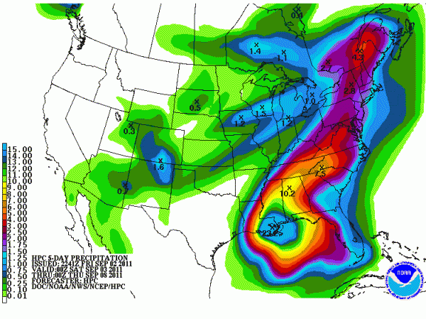
COASTAL RAINFALL AMOUNTS: Through this afternoon, parts of southeastern Louisiana will pick up between 5-8 inches of rain. The pumps in New Orleans will be able to keep up with that most likely. But a state of emergency is in effect for southeastern Louisiana. By Sunday afternoon, an additional 7-9 inches may fall across southeastern Louisiana. Throw in another 3-8 inches of rain on Monday, and you get the picture.
SUNDAY/MONDAY: One inch amounts will spread as far north as a line from Carrollton to Montgomery to Abbeville line on Sunday. Unfortunately (depending on your perspective) Labor Day looks wet across Central Alabama, with 4-6 inch amounts generally north of I-59 and west of I-65. Amounts will taper off to the east, ranging down to 2-3 inches over eastern Alabama. With the rain and clouds, temperatures will be correspondingly cooler, with lower 80s Sunday and Monday.
TUESDAY/WEDNESDAY: By early Tuesday, the center of the weakening depression will likely be over southwestern Alabama. An additional one to two inches of rain will fall over the northern half of the state on Tuesday. It will remain breezy as well as the low moves into the Tennessee Valley by Tuesday night.
Check out the QPF forecast through Wednesday night. That is a large swath of 6-10 inch amounts over West and North Central Alabama, with 4-7 inch amounts over eastern Alabama.
TORNADOES? Landfalling tropical systems can trigger small spin up tornadoes. While we don’t see this as a big problem, we can’t rule out a few of them across the area Sunday and Monday.
Category: Alabama's Weather, Tropical


