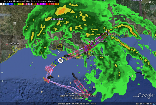
A Mid-Morning Look at Lee
LATEST ON LEE AS OF 10 AM
BULLETIN
TROPICAL STORM LEE ADVISORY NUMBER 8
NWS NATIONAL HURRICANE CENTER MIAMI FL AL132011
1000 AM CDT SAT SEP 03 2011
…LEE APPROACHING ATCHAFALAYA BAY…HEAVY RAINS…STRONG GUSTY
WINDS…AND POSSIBLE TORNADOES LASHING SOUTHEASTERN LOUISIANA…
SUMMARY OF 1000 AM CDT…1500 UTC…INFORMATION
———————————————–
LOCATION…29.3N 91.8W
ABOUT 45 MI…75 KM SW OF MORGAN CITY LOUISIANA
ABOUT 65 MI…100 KM S OF LAFAYETTE LOUISIANA
MAXIMUM SUSTAINED WINDS…60 MPH…95 KM/H
PRESENT MOVEMENT…N OR 5 DEGREES AT 6 MPH…9 KM/H
MINIMUM CENTRAL PRESSURE…993 MB…29.32 INCHES
SOME IMPACTS ALONG THE COAST
Rainfall of 10-15 inches with some 20 inch amounts will fall across SE Louisiana, southern Mississippi and Alabama with 4-8 inches across the Florida Panhandle. Flash flood watches and warnings are in effect.
Storm surge will be 3-5 feet along the Louisiana coast and 2-4 feet along the Alabama/Mississippi coast.
A tropical storm warning is in effect from the Alabama/Florida border westward to Sabine Pass TX. A tropical storm watch is in effect eastward to Destin.
A tornado watch is in effect for southern Louisiana, southern Mississippi/Alabama and the far western Florida Panhandle.
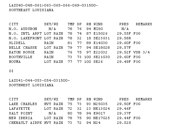
COASTAL OBSERVATIONS
Here are some 9 a.m. observations from southern Louisiana…
NWS MOBILE
The NWS Mobile warns that coastal flooding could impact areas around Fort Pickens, the Mobile Causeway and along the Dauphin Island causeway. Most likely time of flooding is at high tide early Sunday and Monday mornings.
NWS NEW ORLEANS
The NWS New Orleans warns that sustained winds of 40-50 mph with gusts to 70 mph will affect coastal Louisiana.
RIP CURRENTS
The threat of rip currents will be extremely high along the Gulf Coastal beaches of Alabama and Northwest Florida, so if you are at or heading to the beach, stay out of the water! Alert friends and family that might be at the beach this weekend.
Category: Tropical


