Please Travel Only If Necessary.
Significant and widespread flooding continues across a wide area of Central Alabama tonight…if you are in an area being impacted by flooding…stay home and don’t drive tonight…
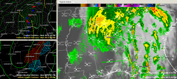
The remnants of Tropical Storm Lee successfully made the transition from tropical to extratopical last night and it gave it a new lease on life.
When this happens, the physical processes that sustain the storm go from being driven by the condensation of the thunderstorms surrounding the core to the interaction between warm and cold air.
The low really strengthened this morning and turned northeast, picking up speed. It traveled just to the southeast of a stalled frontal boundary that extended down from Tennessee through West Alabama and into southern Mississippi. The counter clockwise circulation around the low transported large amounts or rich Gulf moisture up and over the boundary just to the northwest. This made for very efficient rain processes and the rainfall totals are going to be impressive.
Birmingham was standing just under 7 inches of rain at 6:33 p.m. for a storm total (since early Sunday morning).
Flooding is widespread with numerous water rescues required. Flash flood warnings continue for Etowah, Blount, Jefferson, northern Bibb/Shelby and St. Clair Counties. Remember…turn around…don’t drown. Water covering a roadway can easily sweep away a car or person.
Major flooding is ongoing in Hueytown in western Jefferson County…residents along Mississippi Avenue are being evacuated by boat.
The end is in sight however…as the back edge of the rain was moving northeastward through Fayette, Tuscaloosa and Bibb Counties. It will end in the Birmingham area around 8 p.m.
Winds gusted to 49 mph at the Birmingham Airport…and there were several estimates of winds in the 50-60 mph category. They were sustained for several hours. Numerous trees have been felled.
Winds will continue for a few more hours however, slowly dying down as the low tracks northeastward. It is over Central Alabama’s Talladega or Clay Counties at this hour.
ALZ017>021-024>029-060300-
/O.UPG.KBMX.WI.Y.0023.000000T0000Z-110906T1200Z/
/O.NEW.KBMX.HW.W.0001.110905T2341Z-110906T0300Z/
BLOUNT-ETOWAH-CALHOUN-CHEROKEE-CLEBURNE-JEFFERSON-SHELBY-
ST. CLAIR-TALLADEGA-CLAY-RANDOLPH-
INCLUDING THE CITIES OF…ONEONTA…GADSDEN…ANNISTON…CENTRE…
HEFLIN…BIRMINGHAM…HOOVER…COLUMBIANA…PELHAM…ALABASTER…
PELL CITY…MOODY…TALLADEGA…SYLACAUGA…ASHLAND…ROANOKE
641 PM CDT MON SEP 5 2011
…HIGH WIND WARNING IN EFFECT UNTIL 10 PM CDT THIS EVENING…
THE NATIONAL WEATHER SERVICE IN BIRMINGHAM HAS ISSUED A HIGH WIND
WARNING…WHICH IS IN EFFECT UNTIL 10 PM CDT THIS EVENING. THE
WIND ADVISORY IS NO LONGER IN EFFECT FOR THIS AREA.
PRECAUTIONARY/PREPAREDNESS ACTIONS…
A HIGH WIND WARNING MEANS A HAZARDOUS HIGH WIND EVENT IS EXPECTED
OR OCCURRING. SUSTAINED WIND SPEEDS OF AT LEAST 40 MPH OR GUSTS
OF 58 MPH OR MORE CAN LEAD TO PROPERTY DAMAGE.
Trees are down over a wide area, causing power problems. Around 6 p.m., over 100,000 Alabama Power Customers were without power. That number is certain to go higher.
TORNADO WATCH UPDATE
Tornado Watch continues for Autauga, Chilton, Dallas, Elmore, Lowndes, Montgomery and Pike Counties.
It continues for for Barbour, Bullock, Calhoun, Chambers, Clay, Cleburne, Coosa, Lee, Macon, Randolph, Russell, Shelby, St. Clair, Talladega and Tallapoosa till 10:00 PM CDT
Category: Alabama's Weather


