Severe Weather Tuesday

SPC has issued its Day 2 Severe Weather Outlook, and it does include NW Alabama, roughly west of a line from Chattanooga to Birmingham to Demopolis, in moderate risk for severe weather, mainly for Tuesday night. To read their discussion, click here.
This is probably the most impressive severe weather system in the southeast U.S. since last Spring. A warm front is moving northward through Alabama this morning, and warm, moist air from the Gulf of Mexico will have plenty of time to move into the state today and tomorrow, with dewpoints reaching the low to mid 60s. A strong upper-level storm system will develop a surface low on a cold front to our NW tomorrow, bringing strong low-level winds, lift, and wind shear.
Storms may develop tonight over Arkansas, then storms will become widespread and intensify tomorrow in parts of Kentucky, Tennessee, Mississippi, and Louisiana. The storms will move into Alabama tomorrow afternoon/tomorrow evening, and the highest threat for severe weather in central Alabama will be between 2 pm Tuesday and 5 am Wednesday.
With low-level winds (just 5,000 feet up) around 60 knots, and strong low-level shear, any storms that develop may rotate and produce tornadoes. As is often the case this time of year, instability will be somewhat limited, as the sun angle is still low and the days are short. But, this system is bringing plenty of air north out of the Gulf, making this one more dangerous than the one in early January. And, if we get several hours of sunshine Tuesday afternoon pushing temperatures into the 70s, instability may be more of a problem also.
The way it looks now, the highest threat for significant tornadoes may be to our NW, in northern Mississippi and western Tennesee, since storms will move through there during the daytime, and the surface low will be closer. The storms will likely move into Alabama as an intense squall line, with widespread wind damage. However, tornadoes will be possible in Alabama Tuesday night, also. And, things could still change between now and tomorrow.
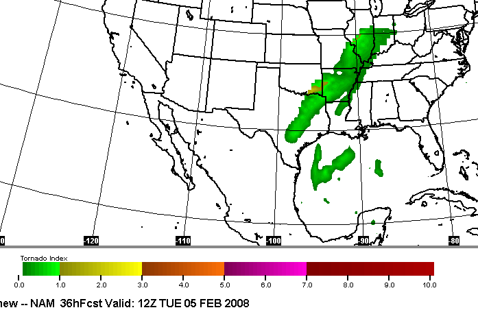
This is a weather system to watch. Attached is a loop (from Harris WeatherCaster), every 3 hours from 6 am Tue through 6 am Wed (remember “Z” time is 6 hours ahead of Central time), of NAM forecast “significant tornado parameter”, which takes instability, shear, and other atmospheric parameters into account to predict the possibility of tornadoes. Larger values mean higher chances for tornadoes. Values greater than 1 typically mean that, if supercell storms form, there is a good chance for tornadoes. The GFS, incidentally, shows a little more instability.
Category: Uncategorized
About the Author (Author Profile)
Subscribe
If you enjoyed this article, subscribe to receive more just like it.


