Severe Weather Analysis 830 pm
**One of the worst tornado outbreaks in the southeast since April 1998 in progress.**
5 pm sounding at Birmingham still shows cap in place, which has, in combination with the lack
of boundaries to focus any convection, apparently suppressed thunderstorms over Alabama so far
today. I think the temporary flare up of scattered thunderstorms this afternoon may have been at
the time of peak heating. Now, with a little surface cooling, things are quiet. We need to be glad as
we have seen the devastation in western Tennessee, northern MS, eastern AR, especially Jackson and Memphis, TN.

Just an example of the research that has been done over the past 25 years or more paying off…the numerical
models, overall, have done a great job with this event so far. SPC placed the high risk area almost perfectly.
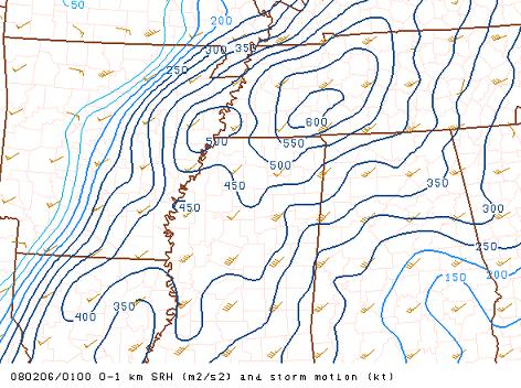
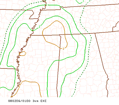
The idea of storm-relative helicity as an indicator of storm rotation, which came into the mainstream about 20 years
ago, and products like the energy helicity index, that have come around more recently, both show strong indications
of storm rotation and tornadoes, respectively, in west TN as of 7 pm, where the tornadoes were.
As Bill Murray shows below, the main line of storms is holding together, and now approaching the Mississippi River.
Just because we’ve avoided severe weather all day, don’t let your guard down! These are not storms that will
fall apart because sunset has occurred. When the storms come through, damaging wind will be likely, and
tornadoes will be a possibility. If any storms form ahead of the line, which is still possible as the main
dynamics come in, a few tornadoes would be likely.
Don’t go to bed tonight without a NOAA Weather Radio on standby, or having someone checking the weather
occasionally.
Category: Uncategorized
About the Author (Author Profile)
Subscribe
If you enjoyed this article, subscribe to receive more just like it.


