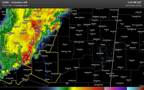
Warnings Continue Across Mississippi
A complex of thunderstorms over northwestern Mississippi continues to push rapidly east southeastward tonight at 45 mph.
There are 4 severe thunderstorm warnings and 2 tornado warnings right now in Mississippi.
The system will move into lower instabilities as it continues east, especially as we lose the heating of the day. But it is bringing its own cold air aloft with it and wind shear value are high enough to help it to hold together across Mississippi.
It should continue to weaken, but will probably hold together enough to make it into Alabama.
It could be into West Alabama’s Franklin and Marion Counties before 8 p.m. and Pickens County before 8:30.
Skies have cleared over Northwest Alabama tonight and fog will form quickly as the clearing spreads southeastward.
The NWS has issued a Dense Fog Advisory for Autauga, Barbour, Bibb, Blount, Bullock, Calhoun, Chambers, Cherokee, Chilton, Clay, Cleburne, Coosa, Dallas, Elmore, Etowah, Greene, Hale, Jefferson, Lee, Lowndes, Macon, Marengo, Montgomery, Perry, Pickens, Pike, Randolph, Russell, Shelby, St. Clair, Sumter, Talladega, Tallapoosa and Tuscaloosa Counties till Feb 02, 8:00 AM CST
Can’t rule out severe weather with it, but the threat should continue to diminish.
Category: Alabama's Weather, Severe Weather


