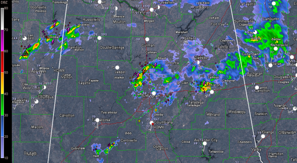
Morning Storms Rumble Through
A complex of storms pushed into North Alabama from Tennessee about 2:30 this morning and has been rumbling slowly southward since then, weakening slowly along the way.
They are not severe, not even especially strong.
But the lightning has produced a few power outages. Lights are reportedly out in parts of Pinson and Center Point, says ABC 3340 Meteorologist Charles Daniel. We had a brief power failure here in Trussville as well.
There is a slight risk outlook for today from the Storm Prediction Center for much of North and Central Alabama. On the update just before 8 a.m., the SPC guys took out much of North Alabama north of the current position of the storms.
The showers and storms currently in the Birmingham area extend from eastern Walker through much of Jefferson, Blount, St. Clair, Etowah, Clahoun, southern Cherokee and Cleburne Counties. They will continue to weaken and it looks like the outflow from them will push into South Central Alabama, firing more storms later today.
More storms were trying to form over southwestern Bibb and Hale Counties. As the outflow from the I-20 storms reaches them, they may intensify.
New storms were firing over Northeast Mississippi and Northwest Alabama. Those storms will move southeastward and will impact areas along and south of the I-22 corridor for the next few hours as well.
The slight risk means there is an increased chance of organized severe weather today, mainly in the form of damaging wind gusts from the stronger storms. It means you should keep an eye on the sky and have a way of receiving any severe thunderstorm warnings that are issued today. Areas south of the Shoals to Cullman to Centre down to Jackson AL, Greenville and Eufaula are in the slight risk outlook. That risk might be trimmed a little further south at 11:30. I would expect areas south of I-22/I-20 to have the best chance for severe storms today.
A frontal system currently back over southern Missouri over across the Ohio Valley will weaken and push southward over the next 24 hours. The remnants of the front (a surface trough) will drift into North Alabama and slowly wash out over the weekend. Rain chances will be higher than normal tomorrow (about 50%) but back off starting Sunday and next week will be drier and hotter again.
Category: Alabama's Weather, Severe Weather


