Severe weather analysis
Models are fairly consistent with each other in the overall pattern, and if this continues, I can already imagine the moderate risk coming out from SPC sometime today, for Friday.
Upper level waves, currently from Montana to southern California, will slowly progress across the U.S. over the next 48 hours. This will help a cold front to move toward Alabama tomorrow. Out ahead of it, southerly flow will move the warm front currently over central Alabama northward, allowing warm, humid Gulf air to flow in. A shallow wedge of cold air will set up over east Alabama again today, but the southerly flow will move the wedge out of most of Alabama by Friday morning. With any sunshine, temperatures could easily approach 80 on Friday.
Buoys indicate Gulf water temperatures in the 70s, and dewpoints near 70 not far offshore. However, the moist air is already in place over south Alabama, with the dewpoint at MGM already 64. So, the moisture is closeby.
Any cap will be broken quickly Friday as temperatures warm, and the latest NAM indicates CAPE values near 2000 J/kg in BHM by Friday afternoon. There will be wind shear in place, with 0-3 km storm-relative helicity values of at least 150-200, plenty for severe storms, including isolated tornadoes, given the large instability. Below is the NAM forecast temperature and wind profile for 4 pm Friday. Notice that a thunderstorm updraft air parcel lifted from the surface (dashed line) is much warmer than the background atmosphere (solid line) for about 30,000 feet, meaning it will buoyantly accelerate upward, since warm air rises.

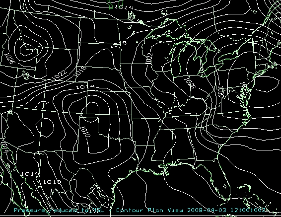
The models are now also showing an upper-level disturbance developing a secondary surface low over north Alabama Friday afternoon. If this happens, wind shear would be larger, and the tornado threat would be significant by Friday afternoon. But, that’s an “if” at this point. Below is a loop of NAM surface pressure every 6 hours, from Thursday 7 am through Saturday 6 am.
The bottom line right now is that if the models turn out to be right, we could be looking at a significant severe weather event on Friday afternoon and Friday evening. The main line of storms will probably come through Friday after sunset, and it will come with the threat of large hail, damaging winds, and isolated tornadoes. However, if scattered severe storms develop ahead of the line Friday afternoon and Friday evening, with a low in north Alabama, those would pose a more significant tornado threat. The models could still be wrong about that part. Go ahead on Thursday and review your severe weather plan, and make sure your NOAA weather radio is ready to go.
Category: Uncategorized
About the Author (Author Profile)
Subscribe
If you enjoyed this article, subscribe to receive more just like it.


