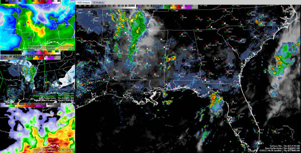
West Central Alabama Storms Get an Early Start
A few showers and storms have broken out in West Central Alabama this morning and they are building in intensity and coverage.
They are south of Tuscaloosa and west of Montgomery over parts of Sumter, southern Greene and Hale Counties. Others are in Choctaw and Marengo Counties, a little further south.
The strongest cells were between Geiger and Gainesville in Sumter County, between Livingston and Epes also in Sumter County and north of Demopolis over southern Greene County. The storm north of Greensboro is producing very heavy rain and gusty winds.
The storms have formed in an area of higher moisture that extends back into Central Mississippi. They are underneath an area of diffluence aloft where the winds are spreading apart. Instead of winds coming together, creating convergence, they are diverging. When this happens up in the atmosphere, it can act to enhance upward motion from below. As they work east southeast, they will encounter more instability to feed on, so they should keep growing. They should remain south of a line from Eutaw to Clanton
Further north, if you expand the SimuAWIPS graphic and look at the top left panel, you see preciptable water, which is an indication of the moisture available in the atmosphere for precipitation. Drier air aloft has led to fairly low value over much of North and North Central Alabama. This could limit our storm chances today.
We are seeing indications that the northwest flow will deliver a thunderstorm complex to our western doorstep by tomorrow morning. If it holds together, it could be a rainy stormy Friday morning across Northwest and North Central Alabama.
Category: Alabama's Weather


