Noon Forecast Update
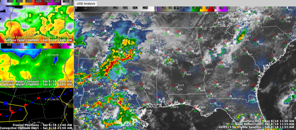
A few showers and storms are forming at this hour over southern Tuscaloosa, Greene and northern Hale Counties in West central Alabama. This activity is pushing east southeastward into Bibb and Perry Counties and will eventually impact Shelby and Chilton Counties a it continues to develop.
Looking at the visible satellite, we see pockets of sunshine over Central Alabama that have allowed temperatures to quickly rise into the 80s.
The front is now lying across North Central Alabama from north of Tuscaloosa to north of Birmingham to near Gadsden. North of that, moisture and instabilities are a little lower. Instability is still pretty decent over much of Central Alabama, with CAPE values running 2-3,000 j/kg south of US-278.
On radar, a complex of showers and storms has moved east southeast out of Arkansas and had entered northern Louisiana and western Mississippi. It shifted a little southward in the past few hours as it edged toward better instability. This activity will arrive in West Central Alabama late this afternoon as a weak surface low in Mississippi tracks eastward along the basically stalled front.
The SPC does have a slight risk all across Central Mississippi coming just into southwestern Sumter and Choctaw Counties in West Alabama. There may be a few severe storms late this afternoon and this evening generally south of a line from Livingston to Selma to Montgomery.
North of that line, scattered showers and storms will develop through the afternoon and through tonight in the vicinity of our front. Can’t rule out an isolated severe storm, but won’t be expecting any big problems.
Highs this afternoon will be in the middle 80s.
Tomorrow will feature the chance for more showers and storms. In fact, storms will be likely tomorrow afternoon and night as another weak low ripples along the frontal system.
Category: Alabama's Weather, Severe Weather


