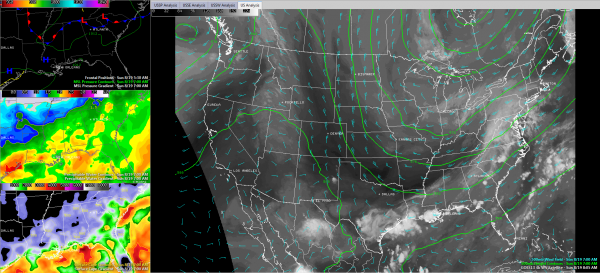
A Few Forecast Changes
With Brian out of pocket on vacation this morning, I thought I would post a few thoughts on the forecast this morning, since it seems it might be changing a bit.
We notice one big difference this morning in what we thought would be and what is. You can see it if you enlarge the image above. Drier air (denoted by the darker colors on the water vapor satellite image) over Arkansas, much of Tenenssee and northern Mississippi.
That is because the western end of the frontal system draped across the Southeast states made a definite southward push overnight behind an upper level disturbance and surface low, the one that produced our evening showers and storms. That low was stronger than anticipated.
The wavy front extends from Harrison AR to Greenville, MS to Tupelo to Muscle Shoals to Chattanooga to Athens, GA this morning. The front and the drier air is progressing southeastward now. How far will it go?
Temperatures were rather uniformly around 70F over North and Central Alabama, very close to the moisture levels. The low dewpoint spreads mean air is nearly saturated. AS a result, low clouds and fog are prevalent, especially over East Alabama, where the fog is quite dense in spots. Dewpoints are in the middle 60s, to near 70F in the I-20 corridor.
With few breaks in the clouds, temperatures will be slow to rise this morning.
Radars relatively quiet. Few showers across the state, mainly in Tennessee Valley and a few over West Central Alabama.
The overnight model runs look a little different. They pick up on this southeastward progression of the front and ratchet down our shower chances for today and tonight. The GFS keeps it dry today north of Cullman,with only a few showers across Central Alabama. Then it is dry overnight north of Montgomery. NAM is in basic agreement. European is on board too, with showers south of us by later this morning.
So for today, we will call for only widely scattered showers and isolated storms across Central Alabama. Mostly dry overnight, unless something changes. Highs will be in the middle 80s. WE will be back in the 60s overnight.
The GFS does predict a low along the Gulf Coast for tomorrow, pushing the boundary back to the north a little and spread some showers and storms back as far north as the I-59 corridor late tomorrow into tomorrow night. We will see. and keep some shower chances in for then.
Rain should be gone by mnidnight tomorrow night and high pressure builds in. No showers Tuesday-Thursday and may be able to take them out for Friday. Typical Labor Day weekend weather it looks like with scattered showers and storms.
Category: Alabama's Weather


