Isaac, And Model Madness
An all new edition of the ABC 33/40 Weather Xtreme video is available in the player on the right sidebar of the blog. You can subscribe to the Weather Xtreme video on iTunes by clicking here.
LET THE FUN BEGIN: Much uncertainty has now been introduced in the future track of Tropical Storm Isaac with a westward shift in the 12Z model runs. Let me say this up front… a NOAA Gulfstream IV research aircraft is in the region this afternoon gathering detailed upper air data that should be ingested in the 00Z model runs tonight, which should bring more clarity to the situation. I think the 00Z and 12Z Friday runs will tell a much clearer story.
THE ISSUE: Isaac now is a very disorganized storm, and it has been hard really getting the exact circulation center nailed over the past 24 hours. But, simple satellite observations suggest the circulation center is displaced to the south over the Caribbean, and this new initialization has led to the westward adjustment in the 12Z model runs.
So… there are more questions than answers now, and we really need to see the 00Z and 12Z runs with the Gulfstream upper air data before totally jumping on the westward shift. Take some time to watch the Weather Xtreme video for the graphics and complete details.
Here are the afternoon talking points on Isaac…
*With a system more to the south, that means there will be less interaction with Hispaniola, and a better chance of intensification over the next 24 hours over the Caribbean.
*Isaac will still have to move over Cuba, but this won’t take long, and the system should emerge into the Southeast Gulf Monday morning as a hurricane.
*If indeed the track more to the west is correct, there is plenty of latent heat energy available along with high SSTs, which would increase the chance of Isaac becoming a significant hurricane early next week on the journey northwest. Remember, there is little skill in forecasting hurricane intensity 5 days in advance. But, a major hurricane is a very real possibility without the interaction with Hispaniola and if the system stays west of the Florida Peninsula. And, that is still a big IF.
*The ECMWF, which has been horrible with tropical systems this summer, remains an outlier to the west; it tries to take Isaac to near the Sabine Pass (the TX/LA border), and that is rejected. The NAM remains the outlier to the east as it keeps Isaac east of Florida. Most of the tropical models, and the GFS ensembles, are now pointing to the Florida panhandle. But, is is very important to note that this not a forecast… just model output. There isn’t much skill in getting a hurricane track correct beyond five days; this is just guidance for planning purposes. The models can shift just as easily to the east over the next 24 hours.
*Having said all of that, a small window is opening for a possible impact on the Central Gulf Coast in the Tuesday-Wednesday time frame next week. I still believe the greatest threat is east of Panama City, but everybody as far west as New Orleans will now need to pay attention. And, if the west track is correct, Isaac could be a very significant hurricane. The east track, which I still believe is more correct, would mean a weaker system and much more rain for the Florida Peninsula, and little impact on the Alabama Gulf Coast. One way or another we will have some long days ahead in weather offices across the Southeast U.S.
*In terms of the inland impact over North and Central Alabama, we will assume for now the main rain shield will remain east of here, but with the westward adjustment just be aware that that could change in a big way over the next 24 hours.
BOTTOM LINE: We will be able to provide a much higher confidence track/intensity forecast of Isaac tomorrow, but for now anybody from New Orleans to Key West could be impacted. The exact impact where you live is simply yet to be determined.
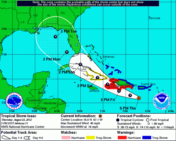
Below is the new NHC track just released…
OUR SHORT TERM FORECAST: No real change in our weather through the weekend; generally dry with mostly sunny days and fair nights. Highs around 90 with slowly rising humidity levels. The weather next week all depends on Isaac.
BEACH WEATHER: Great weather for the Central Gulf through Sunday… about 7 to 9 hours of sunshine each day with just a few widely scattered showers or storms. Highs 87-90; the sea water temperature at the Dauphin Island Sea Lab this afternoon is 85 degrees. The weather beyond Sunday all depends on Isaac.
WEATHER BRAINS: Don’t forget you can listen to our weekly 90 minute netcast anytime on the web, or on iTunes. This is the show all about weather featuring many familiar voices, including our meteorologists here at ABC 33/40.
CONNECT: You can find me on all of the major social networks…
Look for the next Weather Xtreme video here by 7:00 a.m. tomorrow…
Category: Alabama's Weather


