Isaac Model Hokey Pokey
There will be no Weather Xtreme video this afternoon due to travel…..
I am actually authoring this blog post via voice dictation on an iPad as I travel south down I 65 from Nashville, I spoke today to the Middle Tennessee chapter of the National Weather Association.
MODEL MADNESS CONTINUES: The computer models that shifted to the west last night, have shifted to the east this afternoon.
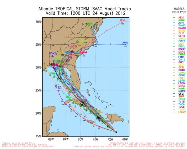
This model hokey pokey leads to a lower confidence landfall solution, but at least some of the central Gulf Coast is still at risk. If the latest model trends happen to be correct, the greatest impact would be generally over Southeast Alabama, the eastern part of the Florida Panhandle and much of South Georgia.
It is important to note that the greatest impact of Isaac will be along and to the east of the circulation center. The 12Z models suggest that the greatest chance of storm surge damage would be from Panama City east, but again this is not carved in stone.
I still believe that Isaac could become a very significant hurricane in the Gulf before landfall. Ocean water temperatures are very warm, and upper air winds seem to be favorable. Also, Isaac will be crossing the warm loop current of the Gulf of Mexico.
In terms of timing, it still looks like the greatest threat of landfall will come late Tuesday night or early Wednesday morning.
The bottom line is that everybody on the Gulf Coast from Gulfport to Apalachicola will need to pay very close attention to weather forecasts over the weekend and go ahead and make preparations now for a possible hurricane arrival Tuesday night or early Wednesday.
NORTH/CENTRAL ALABAMA: Here at home our weather still looks generally dry through Sunday with partly sunny days and fair nights. Any showers over the weekend will be very isolated. Humidity levels will be a little higher and afternoon highs will be close to 90 degrees.
The weather next week all depends on the track of tropical storm Isaac. If the eastward track is correct, the ones we see on the morning model runs, Alabama would be on the dryer side of the storm, with the heaviest rain over Georgia and the Carolinas. But, as we all know, model tracks can change again and will maintain a good chance of rain on Wednesday. We will fine tune the forecast as next week approaches.
I will have a more detailed discussion here on the blog tonight after our 6 o’clock news after I have time to review some more data…
Category: Alabama's Weather
About the Author (Author Profile)
James Spann is one of the most recognized and trusted television meteorologists in the industry. He holds the AMS CCM designation and television seals from the AMS and NWA. He is a past winner of the Broadcast Meteorologist of the Year from both professional organizations.Subscribe
If you enjoyed this article, subscribe to receive more just like it.


