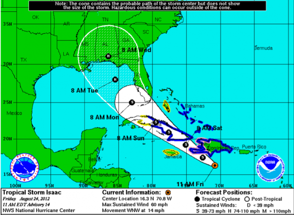
Isaac A Little Stronger
…Top winds up to 60 mph so slowly getting stronger as it gets a little more organized. Storms starting to fill in around the center.
…The storm is moving west northwest. The center is expected to cross the southwestern tip of Haiti tonight. Tropical storm force winds are already affecting the southern Dominican Republic and will spread across Haiti today and tonight.
…Tropical storm force winds will reach eastern Cuba tonight and spread west northwest with the center as it traverses much of the island starting Saturday morning.
…The center will move over the Florida Straits by early Sunday afternoon and strengthening will begin. The center will pass near Key West during the pre-dawn hours Monday and emerge into the southeastern Gulf of Mexico early Monday morning. It should be a tropical storm then but will become a hurricane over the Gulf.
…The forecast track shifted a little eastward as it approaches the northern Gulf Coast.
…Landfall likely late Tuesday night, early Wednesday morning, most likely in Florida Panhandle, but everyone from Southeast Louisiana to the entire West Coast of Florida are in the cone of uncertainty, which reflects average forecast errors through the forecast period.
…Intensity at landfall is problematic. There is plenty of warm water over the Gulf, wind shear is forecast to be light and the storm is expected to slow its forward motion. All of these indications show potential for strengthening. But how disrupted will Isaac be after its encounter with Hispaniola and Cuba? Isaac is beginning to become a large storm, and they are slower to intensify, but obviously can affect a much larger are. Right now, the forecast is for Isaac to be a category one hurricane when it reaches the northern Gulf Coast, but that could very well change and Isaac could be stronger. Potentially much stronger.
…Impact to Central Alabama: It’s early to be very specific, but based on the models and current forecast track, there will likely be heavy rains, embedded thunderstorms and strong winds across the state on Wednesday, spreading from south to north late Tuesday night through the day on Wednesday. I would expect winds across Central Alabama to average 30-50 mph at times with higher gusts. There could be a few tornadoes, mainly east of the track. Rainfall amounts could average 3-5 inches, with higher amounts possible.
Category: Alabama's Weather, Tropical


