No Straight Answers…Yet
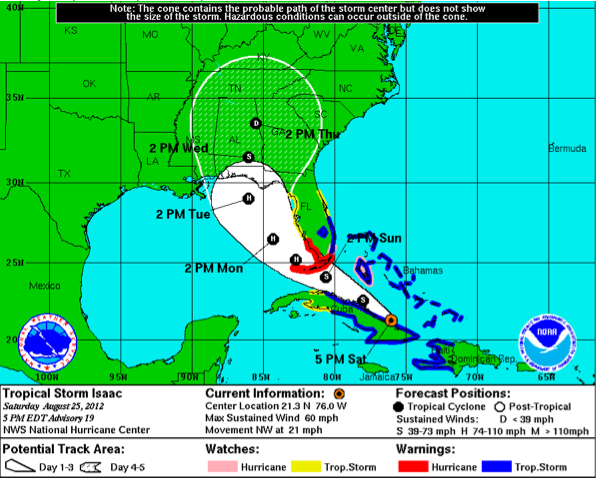
Isaac is still disorganized this evening as it skirts the northern coast of Cuba. But it still has top winds of 60 mph and the central pressure has dropped a little to 997 mb.
The storm will intensify as it moves away from the coast of Cuba. It is still expected to become a hurricane tomorrow night, likely before it crosses the Florida Keys and enters the Gulf of Mexico.
The system will almost certainly strengthen over the Gulf. In fact, the Hurricane Center says that conditions will become very favorable over the northern Gulf. That’s not good news. If it becomes better organized, significant intensification could occur before landfall.
For now, the official forecast calls for Isaac to strengthen to 100 mph by Tuesday afternoon with landfall coming late Tuesday evening, most likely on the Florida Panhandle coast. We don’t like to focus on the “skinny black line” of the forecast track, but it is always interesting to see how it shifts. Now the NHC draws it somewhere around Destin. You want to focus more on the “cone of uncertainty” which surrounds the forecast track, and it indicates that folks all along the Alabama coast and the Northwest Florida coast to the Big Bend area have to be ready to act when warnings are issued.
It is a good time for business and individuals to plan what actions they will take when the specific levels of impact become more apparent. I have heard people say today that they just want a straight answer.
Hello. We would all like a straight answer, but let me assure you, there isn’t one yet. We are fairly sure that a hurricane will impact the northern Gulf Coast this week. Will it make landfall at Destin? Or will it be Southeast Louisiana? Could it go east of Panama City? Will it be a minimal hurricane? A cat two? A major hurricane? You can find a model that will support any of those scenarios.
So what do we do with all this information? We start preparing to execute the plans that will minimize those impacts on our interests? Whether it is moving a parent from Gulf Breeze who is on oxygen, to going and moving the furniture up to the second floor of your condo, to evacuating from Seaside, these are personal decisions that require information. Unfortunately, we can’t give you that specific level of information at this point.
We still have 72 hours until landfall. Tomorrow will be critical, because Monday will be the primary day for action in the hurricane warning areas that have yet to be declared. We will all digest the information the Hurricane Center and local emergency management gives us an make decisions accordingly. We will try to summarize as much information along as we can here and urge you to seek many local trusted sources out as well.
Category: Tropical


