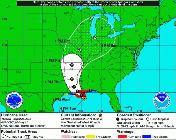
Isaac Nearing Landfall
An all new edition of the ABC 33/40 Weather Xtreme video is available in the player on the right sidebar of the blog. You can subscribe to the Weather Xtreme video on iTunes by clicking here.
ALMOST ON THE COAST: Isaac, now a minimal hurricane, will make landfall soon on the Southeast Louisiana coast around the mouth of the Mississippi River. Top winds are right at 75 mph, and the system is moving northwest at 10 mph.
RIGHT NOW: The outer rain band associated with Isaac is along a line from near Sulligent to Smith Lake to Gadsden and Weiss Lake. To the south, in a very moist and unstable environment (dewpoints are now in the mid 70s over Central Alabama), scattered showers are seen on radar moving from east to west on top of the circulation of Isaac.
TO THE SOUTH: A tornado watch remains in effect for Mobile, Baldwin, Escambia, and Washington Counties in far Southwest Alabama until 7:00. So far no tornadoes have been reported across that part of Alabama, but a few are possible through tonight as Isaac makes landfall.
‘
COASTAL IMPACT THROUGH MID-WEEK: The good news is that the hurricane warning has been lifted for the Alabama Gulf Coast; replaced by a tropical storm warning. Storm surge of 4 to 8 feet is likely along the Alabama coast, with a higher storm surge of 6 to 12 feet to the west over Mississippi and Southeast Louisiana. This will bring some coastal flooding; the Mobile Bay Causeway is flooded and closed this afternoon, and other low lying coastal roads will flood as well.
There will be enough wind to bring scattered tree and power line damage, but nothing really widespread. Our SKYCAM atop the Phoenix All-Suites has a peak wind gust so far at 51 mph in a passing squall. Structural damage is not expected along the coast as Isaac remains a minimal hurricane.
Clearly the biggest issue is rain. Rain amounts of 10 to 20 inches are likely over Southeast Louisiana and coastal Mississippi, with amounts of 8 to 12 inches for the Alabama Gulf Coast. Isaac will be in no hurry to move north over the next 48 hours, and the slow forward motion will mean some tremendous rains and flooding problems along the Gulf Coast, and inland parts of far South Mississippi, Southwest Alabama, and Southeast Louisiana.
INLAND IMPACT THROUGH MID-WEEK: For North/Central Alabama (places like Birmingham, Tuscaloosa, Anniston, and Gadsden), with the very slow movement of Isaac through SE Louisiana I honestly don’t think our weather changes that much tonight and tomorrow. A few passing tropical showers from time to time, but the most widespread rain stays to the south and west for the next 24 hours. Tomorrow will be breezy, with winds gusting to 25 mph at times, but that won’t be enough to bring down any trees or create any major power outages.
It sure looks like Thursday will be our most active day; SPC has a low end chance of tornadoes over the northern half of Alabama with Isaac positioned to the west, and we will have to watch the radar closely Thursday for signs of rotation in the spiral rain bands wrapping around the center of Isaac. The higher tornado threat should come over the western half of the state, but even there I would say it is not a major threat.
And, remember, tornadoes associated with tropical systems are short lived, small, and they don’t last long in most cases.
HOW MUCH RAIN? The QPF numbers have come down a bit for North Alabama, but let me say up front forecasting rain amounts for specific places with a landfalling tropical system is almost impossible to do very accurately. For North-Central Alabama, we will forecast 2 to 4 inches of rain between now and Friday, with potential for isolated amounts to 5 inches. We have to remember we actually have some reports of over one inch of rain today from a few spots in East Alabama.
I don’t expect any serious flooding issues around here, at least on a widespread basis.
The heaviest rain for inland parts of Alabama will come south of a line from Livingston to Camden to Atmore, where totals could approach 10 inches in spots between now and Friday.
SCHOOL CLOSINGS? Don’t expect any need for that across this part of Alabama. Again, kids, I am sorry.
TRAVEL: Across the southern U.S… the worst driving weather will come over South Mississippi and Louisiana due to heavy rain and the potential for flooding. If you are driving anywhere else, you will deal with tropical showers, but you should be safe. Just be sure to pay attention to tornado warnings in case they are issued.
We do not expect any significant arrival or departure delays at Birmingham-Shuttlesworth Airport.
LABOR DAY WEEKEND: Isaac will be long gone, but in the wake of the system a very moist, tropical airmass will cover the Deep South. This means we will have to dodge scattered showers and storms Saturday, Sunday, and Monday. But, on the positive side there will be some decent intervals of sunshine along the way. Looks like highs will be in the 87 to 90 degree range over the holiday weekend. Pretty much the same story for the Gulf Coast.
WEATHER BRAINS: Don’t forget you can listen to our weekly 90 minute netcast anytime on the web, or on iTunes. This is the show all about weather featuring many familiar voices, including our meteorologists here at ABC 33/40. Scroll down for the show notes on this week’s new episode that was recorded last night.
CONNECT: You can find me on all of the major social networks…
I had a great time today visiting with the Hoover New Horizons Club at the City of Hoover Senior Center. Look for the next Weather Xtreme video here by 7:00 a.m. tomorrow…
Category: Alabama's Weather


