Late Night Update
It was interesting to watch the game between the Indians and Twins at Target Field in Minneapolis tonight. Fans were huddled in the stands under blankets as the temperature fell into the 50s by the end of the game. Lows will be in the 40s across much of the Upper Midwest and northern Plains overnight. A sign of things to come. Soon.
CHANGES AHEAD: A very nice change is ahead for across Alabama as a cold front will push into the state early this morning. It will spell much cooler and drier weather for us over the next few days, starting tomorrow.
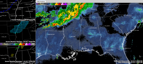
FIRST THE STORMS: Showers and storms formed this afternoon over Kansas and Oklahoma ahead of a cold front. They triggered numerous severe thunderstorm watches and warnings, and even a couple of tornado warnings to the northwest of Alabama.
A severe thunderstorm watch is in effect until 2 a.m. for parts of northern Mississippi and western Tennessee including Jackson TN, Oxford and Tupelo. I doubt it will be extended into Alabama as the showers and storms should continue to weaken as they approach our state. we will continue to monitor them however.
TODAY: By 7 a.m., the cold front will be over Northwest Alabama. Showers will be occurring ahead of the front, especially over western sections. The showers will move northeastward through late morning. Most of them should be over Northeast Alabama by early afternoon. Showers and storms will refire south of the I-59 corridor after lunchtime. They will push southeastward during the afternoon. A few of the storms could be strong to even severe in areas from south of Anniston to Montgomery. Highs will range from the middle 70s over northwestern sections to near 80F in the I-59 corridor to lower 80s over southeastern sections of the area. Skies will be mostly cloudy in the I-59 corridor through midafternoon, but some sunshine will return through the late afternoon hours. Northwestern sections will see sunshine a little earlier.
FOOTBALL FORECAST: Auburn is at Mississippi State for a late morning game with the Bulldogs. Showers will end in Starkville an hour or so before gametime, so tailgating may be a little damp, but the game should be dry, with temperatures in the 70s. You might see some sunshine by the fourth quarter, but don’t count on it. Winds will shift around to the northwest at 10-15 mph. Shift that a couple of hours, and you will get the weather at Tuscaloosa for Alabama and Western Kentucky. Rain should end by 1 p.m. with some clearing in the second half. Temperatures will top out near 80F with those same freshening northwesterly winds.
COOLER OVERNIGHT: As the much drier air moves into the state, readings overnight will fall into the 50s across the state. It will make for very pleasant conditions tomorrow morning.
SUNDAY is shaping up to be a delightful September day, with highs topping out around 80F, bright blue skies and a brisk northerly wind. We will be back in the 50s Sunday night.
THE WEEK AHEAD: High pressure will remain in control of Alabama’s weather through Friday, giving us more fine weather. Highs will be in the middle 80s. Lows will be in the middle 60s.
Category: Alabama's Weather, Severe Weather


