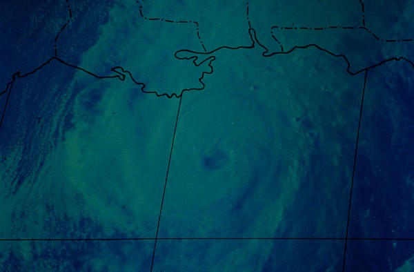
Remembering Hurricane Eloise
On the morning of September 22, 1975, residents along the Alabama and Northwest Florida Gulf Coast were preparing for a hurricane. Eloise was some 350 miles south southwest of Mobile at 6 a.m. that morning and heading north at 11 mph. Eloise had been upgraded to hurricane just after midnight. Boasting top winds of 85 mph, Eloise was expected to continue strengthening before arriving on the coast later that night. The central pressure had fallen to 986 millibars. Tide of 5-8 feet above normal were expected near and just to the east of where the center crossed the coast.
Hurricane warning flags were flying from Grand Isle, Louisiana to Apalachicola, Florida. In Mobile, where the hurricane was expected to come ashore, businesses and homeowners battened down in preparation for the storm. Civil defense officials set up shelters. Dauphin Island was evacuated, even though about ten families decided to thumb their noses at the approaching hurricane and stayed put. Eloise had formed on the 13th, receiving her papers as a tropical depression early that morning while east of the Virgin Islands. She got a name on the 16th while passing north of Cuba. She became a hurricane as she passed north of the Greater Antilles later that same day. Eloise made landfall on the north coast of Hispaniola the next day. A total of forty three people died in the heavy rains and disastrous landslides. Cuba was next, and the island nation’s mountainous terrain knocked the stuffing out of the hurricane. It weakened to a minimal tropical storm. As it curved northwestward toward the Yucatan, it began to slowly strengthen starting on the 20th. It actually continued to strengthen as it moved over the Yucatan and into the southern Gulf. At noon on Tuesday the 22nd, Eloise had slowed a bit and was beginning to turn to the NNE. Forecasters predicted that it would make landfall in the Mobile area. Top winds were up to 100 mph, making it a category two hurricane.
Preparations were complete by late afternoon from Pensacola to the west. During the afternoon, attention shifted from the hurricane to a second attempt on President Gerald Ford’s life outside the St. Francis Hotel in San Francisco. As if to protest her removal from the top story of the day, Eloise began turning more to the northeast and continued to intensify. Warnings were frantically shifted eastward during the late evening, but many people from Fort Walton east to Panama City had already turned in for the night thinking that landfall was going to be much further to the west.
Civil Defense officials had to resort to using loudspeakers on cars as they went street by street in neighborhoods threatened by the change in course and intensity. People fled towns like Destin, Panama City, Apalachicola and Carrabelle in the middle of the night, some still clad in pajamas. By midnight, Eloise had top winds of 120 mph, making it a category three hurricane. It was some 140 miles south of Pensacola. The pressure had dropped to 958 millibars. It was moving northeast at some 17 mph.
Landfall came around 7:30 a.m. CDT between Fort Walton and Panama City. Tides of 12-16 feet were reported east of the center. Panama City took the brunt of the storm surge. No fatalities were directly attributed to Eloise in Florida. Damages there totaled $150 million.
Category: Met 101/Weather History


