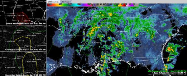
Severe Weather Threat Overnight, Monday
Barometers are low, moisture levels are high, and temperatures are warm tonight across Central Alabama. A warm front has reached the I-20 corridor, and dewpoints will rise toward 70F in Birmingham over the next few hours.
There is not much instability now, but it will increase overnight as rich Gulf moisture continues to be pumped northward by a pretty strong low which is east of Natchez, MS at this hour. It is moving east northeast, and the southeasterly winds ahead of this low will produce favorable low level shear. An trough is producing relatively strong upper level winds.
So we have a typical fall season low instability, fairly strong shear severe weather event unfolding. Through the pre-dawn hours, folks generally south of a line from Carrollton to Clanton to Tallassee to Union Springs have a threat of severe thunderstorms with damaging winds and a chance of a tornado. The best threat is from Choctaw through Marengo and Dallas Counties and further south.
This threat will spread northward to encompass nearly the entire state between 6 a.m. and noon on Monday. After 2 p.m. or so, the threat should be limited to East Alabama. By 6 p.m., it should be completely into Georgia.
There is a tornado watch for much of Southwest Alabama, extending up into Marengo and Sumter Counties until 2 a.m. A new watch will likely be required after midnight further to the east and northeast.
It’s not a big tornado threat, but even an isolated, relatively weak tornado can cause serious damage and injury if it hits your house. So please keep a source for severe weather watch and warning information that will wake you close at hand overnight and on Monday.
Category: Alabama's Weather, Severe Weather


