Things Heating Up To Our Southwest
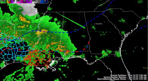
A tornado watch has just been issued for parts of southern Louisiana and southwestern Mississippi.
Thunderstorms are intensifying now over southern Louisiana from west of Lafayette to west of Baton Rouge.
The NWS Lake Charles has a tornado warning on a storm southwest of I-10 to the southwest of Crowley. It has shown good signs of rotation.
In addition, a severe thunderstorm watch continues for much of eastern Texas and western Louisiana until 9 a.m.
The surface low is organizing right now west of Houston. It will pull lots of warm, moist Gulf of Mexico air northward as it intensifies and lifts northeast today and tonight. The stationary front lies from near Fort Polk LA to McComb, MS to Evergreen, AL right now. The western end of it is already starting to lift north.
Upper level wind fields are already strong over Louisiana and this will translate northward today as the low lifts out.
Category: Alabama's Weather, Severe Weather
About the Author (Author Profile)
Bill Murray is the President of The Weather Factory. He is the site's official weather historian and a weekend forecaster. He also anchors the site's severe weather coverage. Bill Murray is the proud holder of National Weather Association Digital Seal #0001 @wxhistorianSubscribe
If you enjoyed this article, subscribe to receive more just like it.


