Cold Again Tonight; Some Mischief Friday?
An all new edition of the ABC 33/40 Weather Xtreme video is available in the player on the right sidebar of the blog. You can subscribe to the Weather Xtreme video on iTunes by clicking here.
COLD AIR IN PLACE: Despite the sunshine, some places over the Tennessee Valley have remained in the 30s all afternoon. Temperatures down this way peaked generally in the mid 40s, about ten degrees below average for late January in Alabama. It will be cold again tonight with most communities winding up in the 20s again early tomorrow.
CLOUDS INCREASE TOMORROW: We expect a general increase in clouds across Alabama tomorrow ahead of another surface boundary, but the day should be mostly dry. I guess a little light rain could break out tomorrow evening, but for now we will leave it out of the forecast. We will see a high around 50 degrees.
THURSDAY: A surface boundary will drop down into Alabama, and bring the chance of a little scattered light rain or drizzle. The high from Birmingham north should be in the 40s with a new surge of shallow, cool air moving into the state. South of Birmingham, the high Thursday should be in the 50s.
FRIDAY: The 12Z models have introduced a little winter weather mischief, but confidence is low now we will actually have any issues. The RPM all of a sudden is showing a period of freezing rain (rain falling in liquid form when surface temperatures are at or below freezing) over Northeast Alabama Friday morning, in part due to a wedge of colder air draining into that part of the state from the northeast. HPC freezing rain probabilities are actually very high for North Alabama early Friday morning…
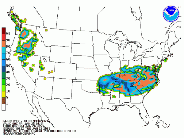
Until we see this showing up consistently in model output we will discount the ice issue for now.
Friday will be cloudy with periods of mostly light rain; rain amounts should be 1/2 inch or less.
The other potential issue is potential for a few snow flakes Friday night on the back side of the departing system; the GFS is actually hinting at some light accumulation for the far northeast corner of Alabama. Snow flakes are unlikely along the I-20 corridor or points south. Take a few minutes to see the Weather Xtreme video for the graphics and details. We really need more consistent model output before we really mention any of this in our public forecast.
THE ALABAMA WEEKEND: Saturday will be cool and dry with a high close to 50, then a southerly breeze kicks in Sunday and we warm into the upper 50s. The weekend looks dry with a mix of sun and clouds both days.
NEXT WEEK: The GFS continues to show a big rain producer at mid-week on Wednesday… and now even a hint of a brief change to snow on the back side of the system early Thursday. Too early to be specific, of course… again see the Weather Xtreme video for the maps and details.
WEATHER BRAINS: Don’t forget you can listen to our weekly 90 minute netcast anytime on the web, or on iTunes. This is the show all about weather featuring many familiar voices, including our meteorologists here at ABC 33/40. Scroll down for the show notes on this week’s new episode.
CONNECT: You can find me on all of the major social networks…
I had a great time today visiting with the kindergarten students at Weaver Elementary… be looking for them on the Pepsi KIDCAM today at 5:00 on ABC 33/40 News. The next Weather Xtreme video will be posted here by 7:00 a.m. tomorrow…
Category: Alabama's Weather
About the Author (Author Profile)
James Spann is one of the most recognized and trusted television meteorologists in the industry. He holds the AMS CCM designation and television seals from the AMS and NWA. He is a past winner of the Broadcast Meteorologist of the Year from both professional organizations.Subscribe
If you enjoyed this article, subscribe to receive more just like it.


