Interesting Temperature Trend
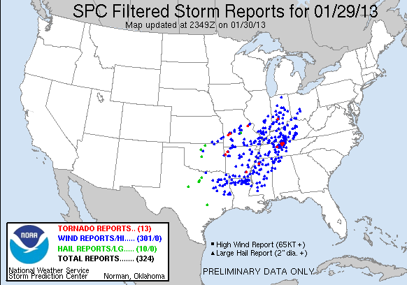
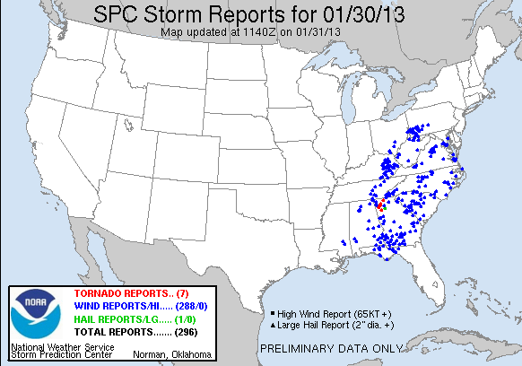
It was another challenging and interesting weather day across the Southeastern US yesterday. The hardest hit places seem to have been in Tennessee and in North Georgia. Preliminary storm report maps from SPC show that the overall two-day event was significant.
Temperatures
While the severe weather is always interesting and attracts a great deal of attention, I find that looking at other weather elements can also be interesting. Yesterday was one of those days where the typical trend in temperature was completely out of whack. A typical day usually shows a nice sinusoidal pattern with the lowest temperature coming around daybreak and the highest temperature coming around mid-afternoon.
Yesterday was NOT typical!! Take a look at the temperature trace below for my weather station in Helena. The temperature actually held steady nearly all night from midnight until just after 8 am when a significant round of rain occurred with the line of storms that moved through Central Alabama. This dropped the temperature a bit more than 10 degrees.
The temperature held fairly steady throughout the day with slow downward trend where you would expect an upward trend as the rain continued. Drier air arrived around 6 pm along with colder air that began a steady downward trend until this morning – a drop of nearly 40 degrees from the temperature just 24 hours ago.
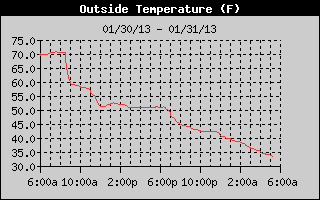
We should see the more typical sine wave pattern in the temperature trace today, but the change will be substantially less than yesterday with a high only in the lower 50s expected. The downward trending of temperature will continue Friday with highs another 10 degrees colder than today.
Rainfall Records
By the way, two new records were set in Central Alabama yesterday. At the Birmingham International Airport, 1.82 inches of rain fell breaking the old record of 1.45 inches set in 1999. And at the weather observing site for Anniston, a record 2.65 inches of rain fell shattering the old record of 1.35 inches set in 1991. Both of those were a tad higher than the 1.75 inches that was recorded by my rain gauge.
-Brian-
Category: Alabama's Weather
About the Author (Author Profile)
Brian Peters is one of the television meteorologists at ABC3340 in Birmingham and a retired NWS Warning Coordination Meteorologist. He handles the weekend Weather Xtreme Videos and forecast discussion and is the Webmaster for the popular WeatherBrains podcast.Subscribe
If you enjoyed this article, subscribe to receive more just like it.


