Evening Notes from the Northeast
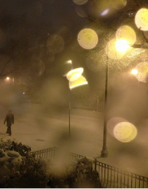
A view from Boston’s Back Bay tonight thanks to Twitter user @knomad.
Some notes from the Northeast:
NEW YORK CITY/LONG ISLAND
CITY SKY/WX TMP DP RH WIND PRES REMARKS
CENTRAL PARK LGT SNOW 30 28 92 NE15G26 29.66F VSB 3/4 WCI 19
LAGUARDIA APRT LGT SNOW 31 28 89 N18G26 29.64F FOG WCI 19
KENNEDY INTL LGTSLEET 31 28 89 N21G32 29.62F FOG WCI 18
NEWARK/LIBERTY LGT SNOW 31 29 92 N23 29.65F FOG WCI 18
TETERBORO LGT SNOW 30 28 93 N16G24 29.65F VSB 3/4 WCI 19
WHITE PLAINS SNOW 29 25 85 N15G23 29.62 VSB 1/2 WCI 18
FARMINGDALE LGT SNOW 30 27 86 N21G32 29.56F FOG WCI 17
ISLIP SLEET 30 29 96 N24G35 29.53 VSB 1/2 WCI 16
SHIRLEY HVY RAIN 33 31 92 N14G24 29.53F FOG WCI 23
WESTHAMPTON RAIN 34 33 96 N25G39 29.53F FOG WCI 21
MONTAUK POINT N/A 33 33 100 N29G48 29.46 WCI 19
…NWS New York City reports that their 7 p.m. balloon was lost after release, so there will be no sounding data.
…Here is a link to some thundersnow video from Middle Island in Suffolk County.
…Coastal flood warnings are in effect. High tide at the Battery tonight was at 7:12 p.m. Tide was a little more than two feet above normal.
…8,000 have no power on Long Island.
…80 mph wind gust reported on the end of Long Island at Montauk a earlier.
…Preparations in the New York City area were taken a little more seriously today in light of Superstorm Sandy at the end of October.
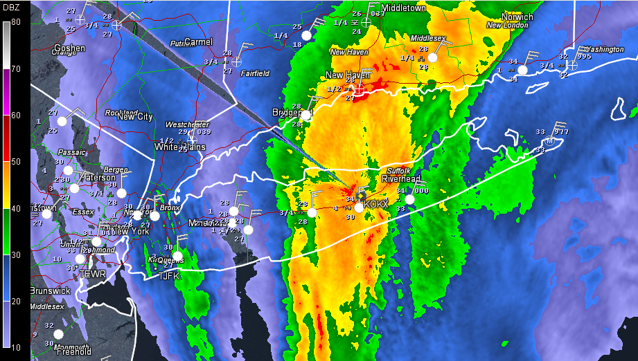
The Upton radar shows heavy sleet and heavy snow in bright colors.
BOSTON/MASSACHUSETTS
CITY SKY/WX TMP DP RH WIND PRES REMARKS
BOSTON SNOW 31 30 96 NE36G52 29.79F VSB 1/2 WCI 15
BEVERLY SNOW 31 28 89 NE28G44 29.81F VSB 1/4 WCI 17
LAWRENCE HVY SNOW 21 17 84 MISG 29.87F VSB 1/4
…63 mph wind gust at Nantucket
…MASSDOT weather station north of Brockton, Massachusetts reported a 91mph wind gust at 7:50pm.
…Moderate to potentially major coastal flooding is expected in the morning on the eastward facing coastlines in Massachusetts. Scituate, Sandwich and Nantucket are expected to experience major flooding around the time of high tide around 9-10 a.m. on Saturday.
…Just saw a new one for me: an Ice Accretion Advisory for coastal areas of the coasts of MA, RI down to Montauk NY.
…Boston forecast:
SUFFOLK MA-
INCLUDING THE CITIES OF…BOSTON
715 PM EST FRI FEB 8 2013
…BLIZZARD WARNING IN EFFECT UNTIL 1 PM EST SATURDAY…
…COASTAL FLOOD WARNING IN EFFECT UNTIL NOON EST SATURDAY…
.TONIGHT…SNOW. SNOW MAY BE HEAVY AT TIMES. ADDITIONAL SNOW
ACCUMULATION OF 12 TO 18 INCHES. VERY WINDY WITH LOWS AROUND 15.
NORTH WINDS 25 TO 35 MPH WITH GUSTS UP TO 50 MPH. CHANCE OF SNOW
NEAR 100 PERCENT.
.SATURDAY…SNOW. SNOW MAY BE HEAVY AT TIMES IN THE MORNING.
TOTAL SNOW ACCUMULATION MORE THAN 2 FEET. WINDY AND COLDER WITH
HIGHS IN THE LOWER 20S. NORTHWEST WINDS 20 TO 30 MPH WITH GUSTS
UP TO 40 MPH. CHANCE OF SNOW NEAR 100 PERCENT.
RHODE ISLAND/CONNECTICUT
…12 inches or snow already at Woonsocket and Smithfield RI
…63 mph wind gust at TF Green Airport near Warwick
…13,000 without power in Connecticut.
Category: Headlines, Winter Weather
About the Author (Author Profile)
Bill Murray is the President of The Weather Factory. He is the site's official weather historian and a weekend forecaster. He also anchors the site's severe weather coverage. Bill Murray is the proud holder of National Weather Association Digital Seal #0001 @wxhistorianSubscribe
If you enjoyed this article, subscribe to receive more just like it.


