Sunny Saturday Ahead
**No afternoon Weather Xtreme video today… I am headed to the BJCC for live weather on ABC 33/40 News at 4, 5, and 6:00 from the World of Wheels**
DRIER AIR WORKING INTO THE STATE: The sky is clearing nicely across North Alabama this afternoon, and the remaining clouds over the central counties of the state will move out tonight. However, look for some fog late tonight and early tomorrow morning with a clear sky, light wind, wet ground, and temperatures dropping to the dew point.
BIG TIME BLIZZARD: The blizzard forecast for the I-95 corridor from New York City to Boston is developing as forecast…
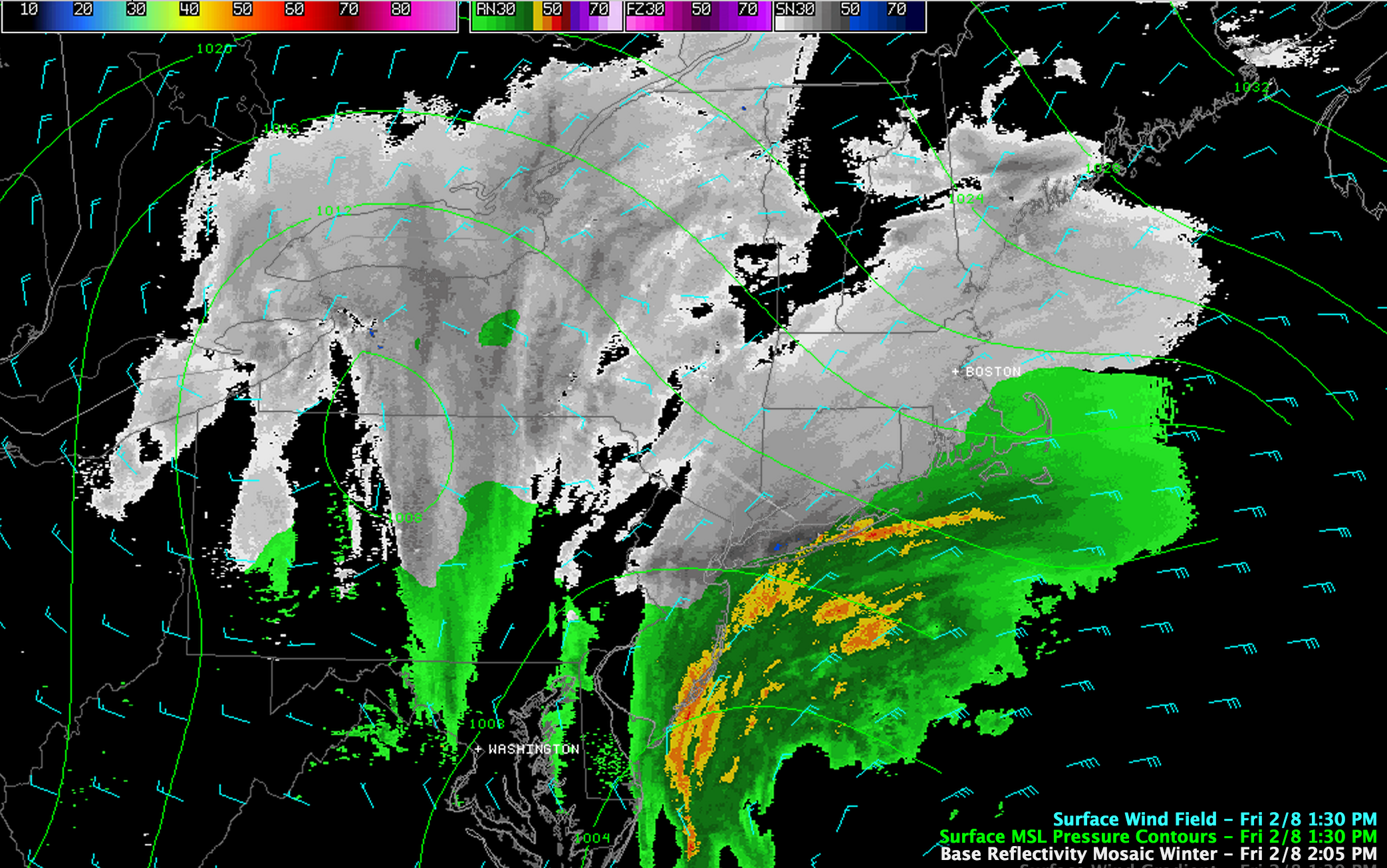
Snow totals of 1-2 feet are likely for NYC, and 2 feet or higher for Boston. Winds will be over 60 mph at times, and travel will be shut down. Widespread power outages are likely as well.
SUNNY SATURDAY: Once the morning fog burns off, tomorrow promises to be a very nice day, with ample sunshine and a high at or just over 60 degrees. But, we are in a very fast moving pattern and the dry weather won’t last long.
Clouds return Sunday along with a gusty south wind; showers develop Sunday afternoon ahead of a storm system deepening across the nation’s heartland.
TWO VERY WET PERIODS: The first shot of rain and storms will come Sunday night into Monday morning. The heaviest rain will most likely come from about 8:00 p.m. Sunday through 8:00 a.m. Monday… strong storms are possible as well but the overall severe weather risk for now looks low.
The second round of rain and storms will come Tuesday, Tuesday night, and into the early morning hours Wednesday. Heavy rain will be the main threat, although strong storms are certainly possible. Flooding is a potential issue as well thanks to saturated soil.
Three day (Sunday, Monday, Tuesday) rain totals of 2-3 inches are likely, with isolated amounts to 4 inches.
Colder and drier air returns Wednesday and Thursday; some snow is likely on the back side of the departing storm system early Wednesday just north of Alabama.
THE LAND OF VOODOO: The GFS hints at a little light snow over North Alabama one week from today (Friday Feb 15), followed by very cold, Arctic air the following weekend (Feb 16-17). And, some hint of snow remains around Feb 19-20. The mid-month period looks cold and unsettled; winter is far from over.
STORM ALERT 2013: Our annual severe weather awareness tour across Alabama continues through February. We will share lessons learned after the April 27, 2011 generational tornado event, along with other amazing weather stories. Learn how to keep your family safe during severe weather, and have a chance to win some cool prizes as well. Here are the remaining Storm Alert tour dates…
February 12 Jasper – CHS Community Building
February 21 Clanton – Jeff State Performing Arts Center
February 26 Ohatchee – Ohatchee High School
February 28 Clay – Clay/Chalkville High School
All shows begin at 6:30… be sure and get there early to get a good seat.
WEATHER BRAINS: Don’t forget you can listen to our weekly 90 minute netcast anytime on the web, or on iTunes. This is the show all about weather featuring many familiar voices, including our meteorologists here at ABC 33/40.
CONNECT: You can find me on all of the major social networks…
I had a great time today seeing kids at Greystone Elementary, and Calera Elementary… be looking for them on the Pepsi KIDCAM today at 5:00 and 6:00 on ABC 33/40 News! Brian Peters will have the video updates tomorrow and Sunday, my next Weather Xtreme video will be posted by Monday morning at 7:00. Enjoy the weekend!
Category: Alabama's Weather
About the Author (Author Profile)
James Spann is one of the most recognized and trusted television meteorologists in the industry. He holds the AMS CCM designation and television seals from the AMS and NWA. He is a past winner of the Broadcast Meteorologist of the Year from both professional organizations.Subscribe
If you enjoyed this article, subscribe to receive more just like it.


