A Very Wet Start to the Week
Hope you enjoyed the sunshine and dry conditions today, because it is about to be a very cloudy and wet forecast through at least Tuesday night. A strong storm system will be heading from the Southern Rockies into the Central Plains and Midwest, where Blizzard conditions are expected. Further to South, rain and strong storms will occur, some of the storms are expected to be severe at times, damaging winds will be the greatest threat from this storm system. That part of the system will be heading towards Alabama overnight tonight, and we can expect rain to be getting to West Alabama by early tomorrow afternoon.
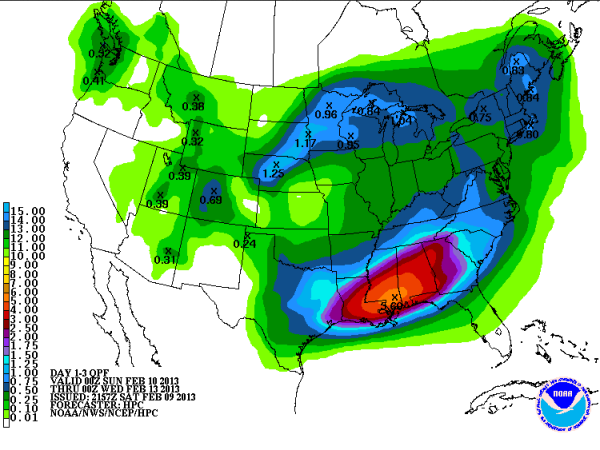
Another issue we may see develop across the state, will be a flooding threat. Since January 1st, Birmingham is already nearly two and half inches above normal for rainfall this year. The slow moving system will be dropping heavy rainfall across the Southeast. A look at the latest Quantitative Precipitation Forecast (QPF) from Sunday evening through Tuesday evening shows very heavy rain fall totals are expected during that time frame. This forecast shows the highest totals over southern Mississippi and southwest Alabama where it looks like areas near Hattiesburg could receive over five inches of rain. Across much of north central Alabama, many areas could expect to receive two to four inches of rain. I know the National Weather Service in Huntsville has already issued a flash flood watch that will take effect Sunday afternoon, and I expect that other NWS offices will issue flood advisories before and during this event. Make sure you stay aware of the changing weather conditions the next few days and never drive through flooded roads…TURN AROUND, DON”T DROWN!!!
Category: Alabama's Weather
About the Author (Author Profile)
Macon, Georgia Television Chief Meteorologist, Birmingham native, and long time Contributor on AlabamaWX. Stormchaser. I did not choose Weather, it chose Me. College Football Fanatic. @Ryan_StinnetSubscribe
If you enjoyed this article, subscribe to receive more just like it.


