Rain Moving In…
**No afternoon Weather Xtreme video today due to travel; we are in Clanton for Storm Alert 2013**
TURNING WET: After a sunny start to the day, clouds and rain are returning to Alabama. Moderate rain is falling over parts of West Alabama early this afternoon…
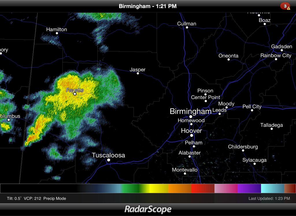
Rain will push eastward through the afternoon hours, becoming widespread statewide tonight.
We note tornado warnings are up for parts of SE Texas and Louisiana where SPC has a “slight risk” of severe weather up, but the storms should weaken as they move into Alabama, and we do not expect any severe weather across the northern two-thirds of the state tonight, although some thunder is certainly possible.
Rain amounts of around 1/2 inch are likely tonight, with isolated totals to 1 inch, mainly south of Birmingham.
TOMORROW: Not much change in our thinking. The latest RPM shows the rain ending for places like Tuscaloosa, Birmingham, Anniston, and Gadsden very early tomorrow morning, in the 5:00 to 8:00 a.m. time frame. During the day tomorrow, the main rain band should be over South Alabama, with clouds hanging tough to the north.
A wave of low pressure will track along the front tomorrow night, and the rain area could move north, up to near I-20. So, we will mention rain tomorrow for Birmingham, Tuscaloosa, Anniston, and points south. Any strong storms will be way down south in the area from Mobile to Dothan, where SPC has a “slight risk” up for tomorrow.
OUR WEEKEND: Looks good. Morning clouds Saturday should give way to a partly sunny afternoon, and Sunday will feature a mix of sun and clouds. Highs over the weekend will be in the 60s; some West Alabama communities could approach 70 degrees Sunday afternoon.
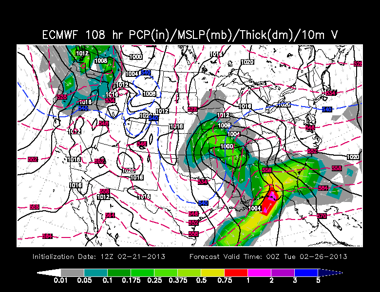
NEXT WEEK: I still think we will have a chance of strong storms Monday, based on the ECMWF. The GFS is drier, but I honestly don’t think it has the correct solution based on the dynamics involved and the potential moisture and instability. SPC has much of Alabama in a severe weather risk Monday (areas south of the Tennessee Valley), and I think they have the right idea. Way too early to be specific about the type of threat or the timing, just something to watch in coming days.
See the ECMWF output for Monday below…
VOODOO LAND: The GFS is still showing an impressive late season cold shot moving into the Deep South around the first of March… see the morning Weather Xtreme video for the details. Will we have an early March snow threat? Nobody knows now.
STORM ALERT 2013 IN CLANTON TONIGHT: Our annual severe weather awareness tour across Alabama continues through February. We will share lessons learned after the April 27, 2011 generational tornado event, along with other amazing weather stories. Learn how to keep your family safe during severe weather, and have a chance to win some cool prizes as well. Here are the remaining Storm Alert tour dates…
TONIGHT Clanton – Jeff State Performing Arts Center
February 26 Ohatchee – Ohatchee High School
February 28 Clay – Clay/Chalkville High School
All shows begin at 6:30… be sure and get there early to get a good seat.
Hope to see many of you at the show in Clanton tonight… look for the next Weather Xtreme video here by 7:00 a.m. tomorrow….
Category: Alabama's Weather
About the Author (Author Profile)
James Spann is one of the most recognized and trusted television meteorologists in the industry. He holds the AMS CCM designation and television seals from the AMS and NWA. He is a past winner of the Broadcast Meteorologist of the Year from both professional organizations.Subscribe
If you enjoyed this article, subscribe to receive more just like it.


