More Showers and Storms
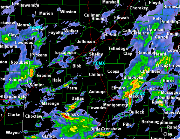
More showers and storms are moving back into North Central Alabama this evening. Heavy rains last night moved out and most of today was dry, but cloudy. Now another energy impulse is moving across the state allowing for additional showers and thunderstorms to develop across much of the region. We have seen a few strong and locally severe storms across the Southeast today. Most of the storms should stay below severe limits, but hail and damaging winds are possible. Lightning and loud claps of thunder are likely and a flooding threat is possible in many area. Some of our southeastern counties remain under a flash flood watch.
If you are heading out this evening make sure you take the rain gear as most every location across the state will receive some rain this evening and tonight. Heaviest activity is currently along I-85 between Montgomery and Auburn. Also watching a strong thunderstorm across Central Wilcox County. For the Birmingham metro we have to look to our west in Pickens and Sumter Counties for the heaviest activity that will impact us later. Light to moderate rain is falling across Tuscaloosa and is making its way into West Jefferson County. Very wet night on tap, but things will improve as we head into tomorrow as sunshine and dry conditions will return.
Category: Alabama's Weather
About the Author (Author Profile)
Macon, Georgia Television Chief Meteorologist, Birmingham native, and long time Contributor on AlabamaWX. Stormchaser. I did not choose Weather, it chose Me. College Football Fanatic. @Ryan_StinnetSubscribe
If you enjoyed this article, subscribe to receive more just like it.


