A Wet Night
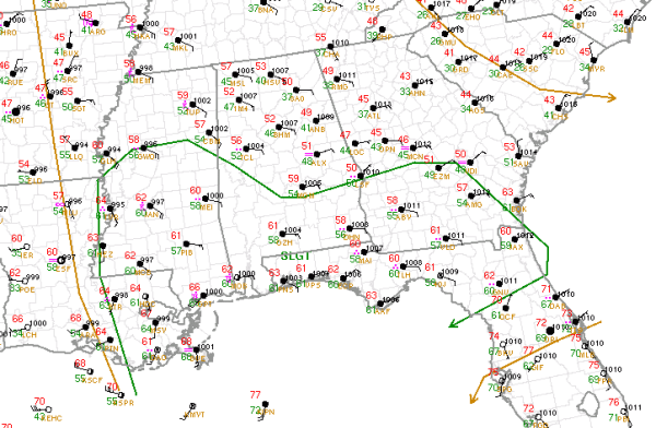
Severe weather threat continues across the southern third of Alabama this evening. The SPC continues a slight risk (outlined in green) for severe weather across the Northern Gulf Coast tonight. The risk runs from near Aliceville down to Selma and over towards Phenix City. The main threat of severe weather will stay south of North Central Alabama as the warm front will not be lifting any farther north this evening. Big storms could impact Mobile, Gulf Shores, Panama City, Dothan and Monroeville overnight, where there is still a threat for damaging winds, hail and a few tornadoes.
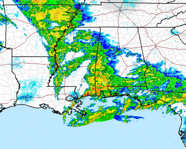
The latest radar mosaic across the Lower Mississippi Valley, shows heavy rain and some scattered thunderstorms continue across the region. Light rain is now approaching the Birmingham metro. Heavier rain is falling along Highway 43 from Tuscaloosa down through Demopolis, Thomasville, Grove Hill and into Mobile. Currently no severe thunderstorms in the state of Alabama, but there are a few thunderstorms to our west that could work into Alabama overnight, but much like the SPC’s thinking, the main severe weather threat stays south of Birmingham. The major concern for many locations will continue to be flooding. Most areas should see heavy rainfall tonight and a flash flood watch remains in effect along a line from Demopolis to Alexander City and points south. Areas in southern Alabama could see on average another 1-3 inches of rain tonight and some isolated spots could see 3-5 inches. Across our part of the state, rainfall totals should range from half an inch to an inch.
Category: Alabama's Weather
About the Author (Author Profile)
Macon, Georgia Television Chief Meteorologist, Birmingham native, and long time Contributor on AlabamaWX. Stormchaser. I did not choose Weather, it chose Me. College Football Fanatic. @Ryan_StinnetSubscribe
If you enjoyed this article, subscribe to receive more just like it.


