8:15 Update
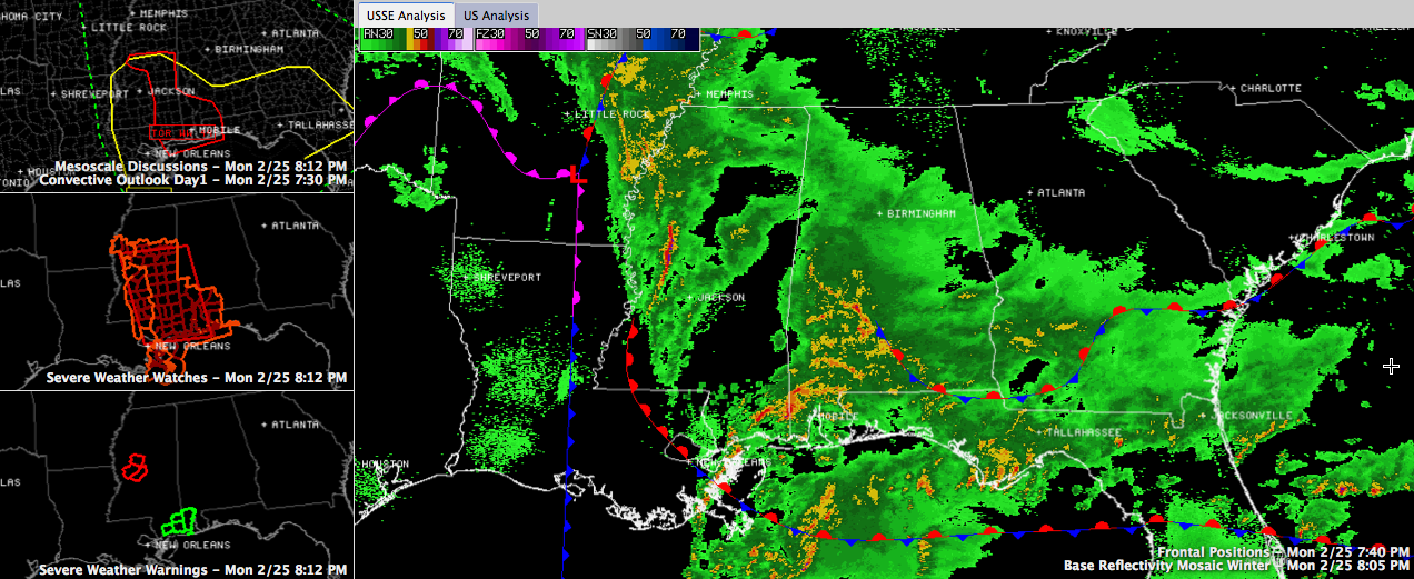
We have been advertising a complex surface pattern over the Southeast for tonight, and it has panned out for sure. Look at the surface features in the right panel of the image. You can see surface low southeast of Little Rock with a warm front lifting across Mississippi before it curves southward and turns stationary just off the Gulf Coast.
An easterly wedge front is located over Southeast Alabama, curving back across southern Georgia and then along the South Carolina Coast. This front marks the southerly edge of cooler, drier air that is coming in from the northeast. This cooler air has kept us stable all day, and served to keep the warm front at bay.
A cold front is overrunning the warm front over southern Arkansas and northern Louisiana. It is depicted by the purple frontal boundary, which is an occluded front. The cold front extends into the Gulf of Mexico.
There is a new tornado warning for Holmes, Madison and Yazoo Counties, including Yazoo City, in western Mississippi. Strong winds at 5,000 feet are lifting across Mississippi in the vicinity of the warm front.
Severe weather is still likely this evening along and south of the warm front. The tornado watch for the southwestern two thirds of Mississippi, southeastern Louisiana, southwestern Alabama and extreme northwestern Florida has been extended until 10 p.m.
The severe weather threat may lift as far north as Sumter, Greene, Hale and Dallas Counties this evening.
Elevated thunderstorms cover much of the western half of South Central Alabama. These storms and area of moderate rain are lifting north northeast. This activity will lift into Tuscaloosa, Bibb, Chilton, Autauga and Lowndes Counties over the next hour. It will be accompanied by heavy rain, plenty of lightning and gusty winds as well as some small hail.
After this activity passes, there could be a period of strong winds thanks to a wake low. Wind advisories are already in effect.
Category: Alabama's Weather, Severe Weather
About the Author (Author Profile)
Bill Murray is the President of The Weather Factory. He is the site's official weather historian and a weekend forecaster. He also anchors the site's severe weather coverage. Bill Murray is the proud holder of National Weather Association Digital Seal #0001 @wxhistorianSubscribe
If you enjoyed this article, subscribe to receive more just like it.


