A Late Morning Look at Alabama’s Weather
Click on the image to expand it. Then explore the surface details discussed, check out the satellite imagery, see the radar and examine the severe weather situation.
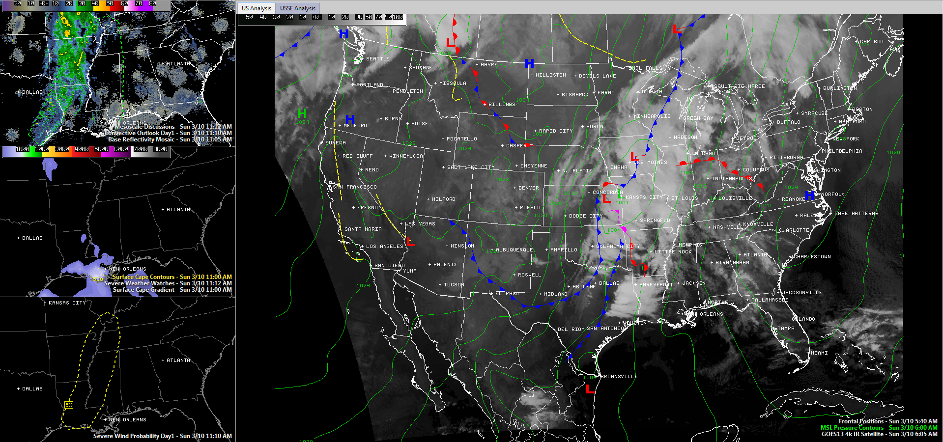
A windy and mild late winter Sunday is in progress across Central Alabama. Southeasterly winds are averaging 10-20 mph, occasionally gusting to near 30 mph this morning. That will continue through the day and through much of the overnight as we remain sandwiched between a surface low between Concordia, KS and Kansas City. That surface low is not very strong, with a minimum pressure of 1001 millibars. But it is running up against strong high pressure stubbornly centered near Columbia SC, which has a pressure of 1026 millibars. Squeezing all those isobars together has resulted in a strong pressure gradient between the two systems and some strong southerly winds.
Temperatures over North and Central Alabama are in the lower and middle 60s. Sky conditions are all over the board, with sunshine in many areas, but patches of clouds in others. Heavy cloudiness is over Mississippi however, and this will move over the state from the west during the afternoon hours.
Temperatures will make the 70s in most locations, although cloudier spots will struggle to get past 70F.
Rain covers much of Missouri, Arkansas and northwestern Louisiana, down into northeastern Texas at this hour. There is some lightning over eastern Texas into Louisiana, but there is no severe weather at this hour. There were a couple of severe thunderstorm and tornado warnings earlier this morning in Arkansas and Texas, but that activity has weakened.
The SPC has a low end 2% tornado probability for today over the Mississippi Delta region of Mississippi and Louisiana and a broader 5% risk down the Mississippi River from the Missouri Bootheel to Natchez MS and back into Central Louisiana and Eastern Texas. This is not enough to trigger a slight risk outlook for any area.
Storms will strengthen this afternoon to our west as the heating of the day increases instabilities and wind profiles remain fairly strong. But the storms will push into the Northwest Corner of Alabama around midnight and will slowly work their way into West Alabama during the predawn hours. They will reach Tuscaloosa around sunrise and Birmingham between 7-9 a.m. Heavy rain and gusty winds will be the main factors.
The rainfall could get a little heavier as it moves over into eastern sections of Alabama Monday afternoon. This will translate into about an inch of rain in the I-59 corridor, with heavier amounts northwest and southeast of the corridor. 1-2 inch amounts will be common with the heavier rain, with some isolated 2+ inch amounts. Storm activity could increase a bit as well, but still, there won’t be enough instability for strong or severe storms.
The rain should be out of all but southeastern sections of the area by Monday evening. We will start off in the 50s Monday morning, and the mercury will barely move during the day over northwestern sections. Folks in the I-59 corridor should rise slightly to around 60F. Areas down toward Alex City will get into the middle 60s tomorrow.
Look for cooler conditions behind the system for midweek. Lows Tuesday, Wednesday and Thursday will be in the 30s, with a chance for a light freeze in there on one or more of the mornings for colder locations. Highs will be in the upper 50s to near 60F. Temperatures will start to moderate by late in the week, returning to near 70F for the weekend, which looks to be pretty nice for now.
Category: Alabama's Weather
About the Author (Author Profile)
Bill Murray is the President of The Weather Factory. He is the site's official weather historian and a weekend forecaster. He also anchors the site's severe weather coverage. Bill Murray is the proud holder of National Weather Association Digital Seal #0001 @wxhistorianSubscribe
If you enjoyed this article, subscribe to receive more just like it.


