Disturbances in the Flow
An update from the Weather Center at 1:35 p.m…
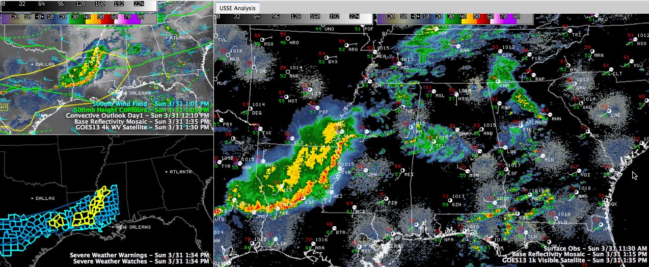
An area of moderate to heavy showers is pushing from west to east across West Central Alabama at this hour. The heaviest rain is across Tuscaloosa County, poised to push across the City of Tuscaloosa. I couldn’t find any lightning, but we can’t rule out an isolated stroke or two if the convection grows.
The activity is being fed a steady diet of slightly unstable air, so it will probably hold together.
The showers are associated with another disturbance in the upper flow across the area. Watching radar animations, you can see a subtle spin in the precipitation echoes.
Skies are mostly cloudy, but there are a few breaks in the clouds across the Black Belt counties, such as Hale, Marengo, Dallas and Perry. Sunshine is evident on the Skycam from Selma.
The sun was also trying to break out across North Central Alabama, around Jefferson, Blount and Cullman Counties. Temperatures are climbing through the lower 60s, heading toward highs in the middle and upper 60s generally.
Looking back to the west, a line of strong to severe thunderstorms continues pushing southeastward across Louisiana and into western Mississippi. It has been pushing southeast but appears to be turning more east in the upper flow. It may affect areas generally south of a line from Aliceville to Calera to Roanoke later.
Outside of this complex of storms, scattered storms will develop over North Central and North Alabama this afternoon and evening ahead of a cold front that will cross the area tonight.
Organized severe weather is not expected across North Central Alabama, but along and south of US-80, there may be enough instability for several severe thunderstorm warnings as the complex moves across the area. And we can’t rule out an isolated severe thunderstorm over the rest of the area this afternoon and evening if instability can fuel thunderstorm updrafts sufficiently.
Tuscaloosa had already picked up one half inch of rain (0.48″) through 1:30.
Category: Alabama's Weather
About the Author (Author Profile)
Bill Murray is the President of The Weather Factory. He is the site's official weather historian and a weekend forecaster. He also anchors the site's severe weather coverage. Bill Murray is the proud holder of National Weather Association Digital Seal #0001 @wxhistorianSubscribe
If you enjoyed this article, subscribe to receive more just like it.


