Severe Thunderstorm Warning for Dallas County til 4:45 p.m.

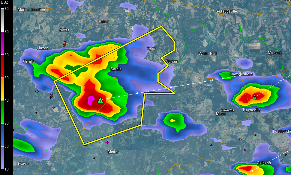
A severe thunderstorm has developed south of Selma. It is moving east northeast.
The main hail core, with hail to the size of quarters, will pass south of Sardis and Benton and towards Lowndesboro.
Here is the polygon that is the warning.
THE NATIONAL WEATHER SERVICE IN BIRMINGHAM HAS ISSUED A
* SEVERE THUNDERSTORM WARNING FOR…
EAST CENTRAL DALLAS COUNTY IN SOUTH CENTRAL ALABAMA…
* UNTIL 445 PM CDT
* AT 407 PM CDT…THE NATIONAL WEATHER SERVICE INDICATED A SEVERE
THUNDERSTORM CAPABLE OF PRODUCING QUARTER SIZE HAIL…AND DAMAGING
WINDS IN EXCESS OF 60 MPH. THIS STORM WAS LOCATED NEAR DALLAS
LAKE…OR 12 MILES SOUTH OF SELMONT-WEST SELMONT…AND MOVING
NORTHEAST AT 25 MPH.
* LOCATIONS IMPACTED INCLUDE…
TYLER.
Category: Alabama's Weather, Severe Weather
About the Author (Author Profile)
Subscribe
If you enjoyed this article, subscribe to receive more just like it.


