A Little Cooler Today; Rain Thursday
An all new edition of the ABC 33/40 Weather Xtreme video is available in the player on the right sidebar of the blog. You can subscribe to the Weather Xtreme video on iTunes by clicking here.
A TOUCH COOLER: A cold front passed through Alabama in dry fashion last night; the airmass now in place will knock about 5 to 8 degrees off the high temperatures we enjoyed yesterday. With a partly sunny sky, we project a high in the mid to upper 60s for most communities today.
Clouds thicken tonight, and tomorrow looks to be a mostly cloudy day as a storm system gathers strength to the west. A little model madness… the 4km NAM wants to bring some rain in here during the day thanks to isentropic lift, while the GFS is dry. We will probably introduce the risk of some light rain during the daytime hours tomorrow if the 12Z run of the NAM is similar.
THURSDAY SOAKER: One way or another, the big rain day will be Thursday thanks to a deep surface low just south of Mobile Bay. Rain amounts of at least one inch are likely here, and it should rain most of the day. It will be a cool rain with temperatures in the 50s, and there is no risk of severe weather with the surface low so far south.
Some rain could linger into Friday morning as the surface low moves northeast up the Atlantic coast; I doubt if we see any sunshine Friday, and we stay cool with many places having a hard time getting out of the 50s.
FINE WEEKEND: Saturday and Sunday still look delightful. Highs in the mid 70s… the low Saturday morning will be in the 40-45 degree range, and Sunday morning’s lows will be in the 49-53 degree range. A great weekend to get outside and enjoy the fresh air.
NEXT WEEK: For us, it should be the warmest week so far this year with highs not too far from 80 degrees for the first half of the week. To the west, a deep upper trough should bring a significant severe weather/tornado setup to areas west of Alabama Monday and Tuesday. And, it could very well bring the risk of strong to severe storms to our state by Wednesday or Thursday… it remains to be seen what kind of threat, and the exact timing. See the Weather Xtreme video for the graphics, maps, and more details.
AT THE BEACH: Today will be mostly sunny on the Gulf Coast from Panama City west to Gulf Shores, but clouds return tonight with a chance of showers tomorrow. Rain and storms are likely Thursday; rain could be heavy in spots. The sky will clear Friday, followed by a beautiful weekend with highs in the low 70s on the immediate coast. Sea water temperatures are generally in the mid 60s.
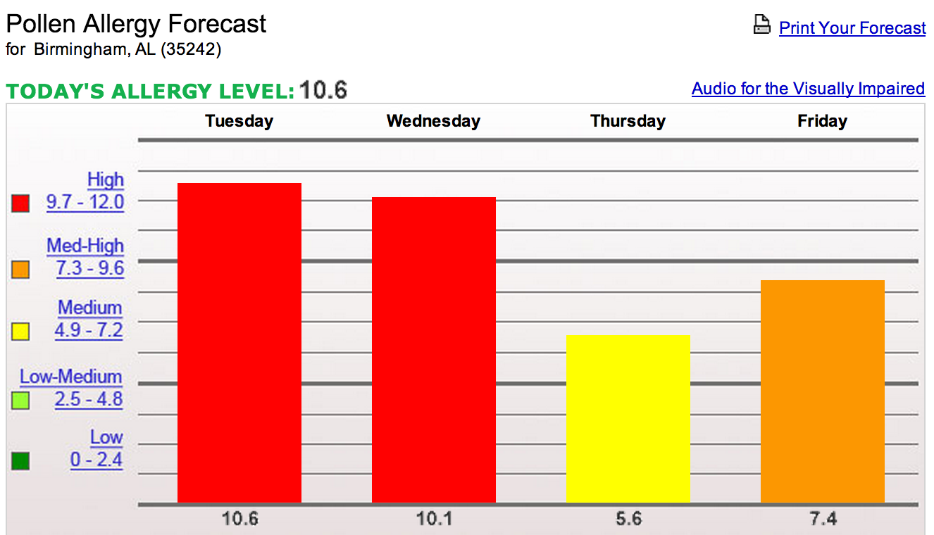
POLLEN: Levels are expected to be very high today and tomorrow before the rain helps Thursday… here is the outlook from pollen.com
WEATHER BRAINS: Don’t forget you can listen to our weekly 90 minute netcast anytime on the web, or on iTunes. This is the show all about weather featuring many familiar voices, including our meteorologists here at ABC 33/40. Scroll down for the show notes on the new episode we recorded last night. Good to have Dr. Laura Myers on the show with us discussion the social science aspect of the severe weather warning process.
CONNECT: You can find me on all of the major social networks…
Look for the next Weather Xtreme video here by 4:00 this afternoon… enjoy the day…
Category: Alabama's Weather
About the Author (Author Profile)
James Spann is one of the most recognized and trusted television meteorologists in the industry. He holds the AMS CCM designation and television seals from the AMS and NWA. He is a past winner of the Broadcast Meteorologist of the Year from both professional organizations.Subscribe
If you enjoyed this article, subscribe to receive more just like it.


