Warm Days; Severe Storms Possible Thursday
An all new edition of the ABC 33/40 Weather Xtreme video is available in the player on the right sidebar of the blog. You can subscribe to the Weather Xtreme video on iTunes by clicking here.
WARMEST SO FAR THIS YEAR: A few mid-afternoon temperatures around Alabama include 84 at Tuscaloosa, 83 at Birmingham and Anniston, and 82 at Gadsden. We have a mix of sun and clouds, and the pollen levels remain sky high, giving the sky a hazy tint. Nothing on the radar around here.
TO THE WEST: SPC has actually removed the “moderate risk” of severe weather for parts of TX and OK… now we just have the standard “slight risk” from Texas up into the southern part of Iowa for the rest of this afternoon and tonight. Seems the capping inversion will keep a lid on things over OK and TX this evening until colder air aloft arrives tonight, reducing the tornado threat to some degree.
The severe weather risk expands east tomorrow, and runs from the western Gulf Coast up through the Midwest, and over to the New Jersey coast. The highest severe weather probabilities tomorrow are over parts of East Arkansas and Southeast Missouri. A few significant tornadoes are possible in this region tomorrow afternoon, but here in Alabama another warm, dry day is likely with a mix of sun and clouds and a high in the low to mid 80s. South winds will pick up tomorrow afternoon, gusting to over 25 mph at times.
BARONS HOME OPENER: The Birmingham Barons will play their first home game in the new Regions Field in downtown Birmingham tomorrow night. The weather will be warm and windy; about 80 degrees at the first pitch, falling to near 75 by the final inning. Only a 10-20 percent risk of a brief shower during the game.
THE ALABAMA SEVERE WEATHER THREAT THURSDAY: The new batch of computer model data (12z runs) are actually now in pretty good agreement, giving us good clarity for the event. Generally speaking, not much change from what we posted here this morning.
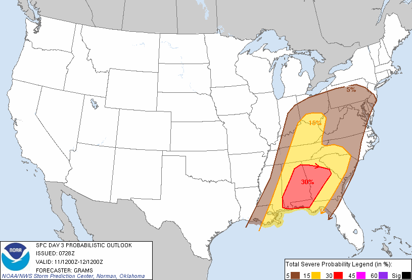
*The main window for severe weather in Alabama will come from 9:00 a.m. until 9:00 p.m. Thursday. The core risk will be during the afternoon hours as a squall line passes through the state.
*Wind fields are a little higher on the morning model runs; 850 mb winds (the low level jet) of 50 knots are showing up, and it won’t take too much to get that down to the surface. The greatest risk will come from strong, perhaps damaging straight line winds along the line of storms. Please remember to heed severe thunderstorm warnings and pay attention to them, and the wording used in those warnings.
*The primary limiting factors are low instability values (surface based CAPE values are generally under 1,000 j/kg), and marginal low level shear. But, please understand that even with these less than impressive values, severe storms are still a pretty good possibility, and we sure can’t rule out an isolated tornado. This is April in Alabama, after all. And, with thunderstorms, expect the unexpected.
*SPC has all of Alabama (all 67 counties) in the standard “slight risk” of severe weather Thursday… the higher severe weather probabilities are generally south and and east of Birmingham…
Take a few minutes to watch the afternoon Weather Xtreme video for all of the maps, graphics, and details.
It is likely that severe weather watches and warnings will be required for parts of the state… please remember that you should NEVER rely on an outdoor warning siren for warnings; a NOAA Weather Radio is the baseline, and it is preferable that you also have a good smart phone app so you can get warnings on the go. We like the apps MyWarn, and iMap WeatherRadio. Both allow you to watch ABC 33/40’s long form severe weather coverage from the app if we go into “wall to wall” coverage.
FRIDAY AND THE WEEKEND: Sunshine returns Friday as dry air blows into the state; the high will drop into the upper 60s. Saturday will be a simply delightful day with sunshine in full supply. We begin the day in the low 40s, but rise quickly to a high around 70 degrees. We should note some of the normally colder spots across North Alabama could see mid 30s early Saturday with a touch of light frost, but most of the state will not have that issue.
Sunday will be partly sunny with a high in the mid to upper 70s as a warming trend begins.
NEXT WEEK: A moist airmass moves up into Alabama from the Gulf… a few scattered showers are possible Monday and Tuesday, but nothing really heavy or organized. These two days will be warm and humid… showers and storms should be more widespread Wednesday as an upper trough approaches from the west.
WEATHER BRAINS: Don’t forget you can listen to our weekly 90 minute netcast anytime on the web, or on iTunes. This is the show all about weather featuring many familiar voices, including our meteorologists here at ABC 33/40. Scroll down for the show notes on this week’s new episode we recorded last night.
CONNECT: You can find me on all of the major social networks…
I really had a wonderful time today seeing all of the kindergarten and first grade students at Cullman City Primary School…. be looking for them on the Pepsi KIDCAM today at 5:00 on ABC 33/40 News! The next Weather Xtreme video will be posted here by 7:00 a.m. tomorrow…
Category: Alabama's Weather
About the Author (Author Profile)
James Spann is one of the most recognized and trusted television meteorologists in the industry. He holds the AMS CCM designation and television seals from the AMS and NWA. He is a past winner of the Broadcast Meteorologist of the Year from both professional organizations.Subscribe
If you enjoyed this article, subscribe to receive more just like it.


