

Severe Storms Possible After Midnight
An all new edition of the ABC 33/40 Weather Xtreme video is available in the player on the right sidebar of the blog. You can subscribe to the Weather Xtreme video on iTunes by clicking here.
THE STORMS OF APRIL: This is the core of the tornado season, so having a severe weather threat is not unusual in Alabama this time of the year. And, we will deal with another risk of severe storms late tonight and into tomorrow morning.
During the day, our weather should be warm and generally dry with a high between 82 and 85 degrees along with a mix of sun and clouds. But, to the west, big storms will flare up over parts of Mississippi, Arkansas, and West Tennessee later in the day.
THE ALABAMA SEVERE WEATHER RISK: Here are the details of the threat…
*SPC has introduced a “moderate risk” of severe weather for the northwest corner of Alabama for late tonight (after midnight), with a “slight risk” as far east as Scottsboro, Montgomery, and Chathom. Muscle Shoals/Florence and Hamilton are in the moderate risk, while places like Tuscaloosa, Cullman, Birmingham, and Greensboro are in the slight risk.
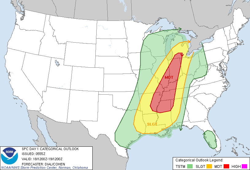
*The core risk of severe weather in Alabama will come from midnight tonight through 6:00 a.m. tomorrow. While the rain could linger into the late morning hours over Central and East Alabama, the storms should be under severe limits to the south and east of Birmingham. The severe weather risk is low for places like Anniston and Gadsden.
*All modes of severe weather are possible over Northwest Alabama (the moderate risk area)… including the threat of damaging straight line winds, hail, and a few isolated tornadoes. As the storms move eastward, the primary risk becomes straight line winds over North-Central and West-Central Alabama (the slight risk area), although an isolated tornado can’t be totally ruled out.

*Rain amounts of about one inch are likely as the storms move through, but the threat of flash flooding is generally low.
*Since this is a “middle of the night” event, it is very important for all Alabamians to have a NOAA Weather Radio so you won’t miss any warnings while your family is sleeping. You will not hear an outdoor warning siren in your home.
*The rain will be ending from west to east tomorrow morning. Models don’t agree well on the specific timing, but I do believe most all of the rain will be out of Alabama by early afternoon. We do note the NAM is slower… take some time to see the Weather Xtreme video for all of the maps, graphics, and details.
Tomorrow will be cooler with a high in the 60s.
SUNNY WEEKEND: Expect sunshine back in full supply Saturday and Sunday. We should point out the NAM model is now printing a low of 37 degrees early Saturday… meaning there could be a touch of light frost across the coldest pockets of North Alabama. The high Saturday will be in the 67-70 degree range, followed by low to mid 70s Sunday. The humidity over the weekend will be low.
NEXT WEEK: The next organized round of rain and storms should arrive late Tuesday night into Wednesday.
WEATHER BRAINS: Don’t forget you can listen to our weekly 90 minute netcast anytime on the web, or on iTunes. This is the show all about weather featuring many familiar voices, including our meteorologists here at ABC 33/40.
CONNECT: You can find me on all of the major social networks…
We will be at the Publix in Pell City today from 3:30 until 6:30 p.m. programming NOAA Weather Radio receivers… if you need help come see us. I will have updated forecast notes posted here by 4:00 this afternoon… enjoy the day…
Category: Alabama's Weather
About the Author (Author Profile)
James Spann is one of the most recognized and trusted television meteorologists in the industry. He holds the AMS CCM designation and television seals from the AMS and NWA. He is a past winner of the Broadcast Meteorologist of the Year from both professional organizations.Subscribe
If you enjoyed this article, subscribe to receive more just like it.


